Select Item below to DOWNLOAD - Once item is selected, right click and choose 'save as'
bc0d9a8e-658d-4332-bd7d-783e058535b9
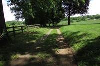
Remains of the Circular Drive at Thomas Farm
A wooden board fence follows the left side of a two-track dirt driveway, shaded by leafy deciduous trees and bordered by open field.
Historically, the entrance lane to the farm led from Georgetown Pike (now Araby Church Road) to the main house. The entrance drive still follows this route and is lined with many old-growth, overarching deciduous trees.
Although the circular drive that existed in the 1800s is no longer extant, a portion of the lane that extended along the west side of the house remains as a visible trace.
Permission must be secured from the individual copyright owners to reproduce any copyrighted materials contained within this website. Digital assets without any copyright restrictions are public domain.
NPS / NCR CLP 2019
Public domain:Full Granting Rights
Image
Monocacy National Battlefield, Code: MONO
National Capital Region, Code: NCR
National Capital Region, Code: NCR
Monocacy National Battlefield, Frederick County, Maryland
Latitude: 39.3577003479004, Longitude: -77.4024963378906
Latitude: 39.3577003479004, Longitude: -77.4024963378906
05/20/2019
05/20/2019
Public Can View
Wednesday, June 5, 2019 11:18:23 AM
Wednesday, June 5, 2019 11:18:23 AM
MONO_Thomas Farm_2019_05_21_ E_Circular Drive .JPG
Canon Canon, Canon PowerShot SX500 IS
1/400 sec at f / 4
4.3 mm
ISO 100
Tuesday, May 21, 2019 4:53:08 AM
jpg
4.6 MB
Scenic