Select Item below to DOWNLOAD - Once item is selected, right click and choose 'save as'
b79f3059-5e55-4f67-98fb-577f2cc756e2
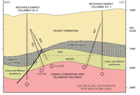
West–East Cross-Section Through the Mist gas Field
Schematic west–east geologic cross-section of the Mist gas field in Oregon showing the gas reservoir and reservoir seals.
The Cowlitz Formation consists of the Clark and Wilson sandstone, which contains the gas, and the Cowlitz Shale, which acts as a seal above the hydrocarbon reservoir. A normal fault acts as a lateral seal. The crooked lines represent unconformities, which bound the Cowlitz Formation.
Permission must be secured from the individual copyright owners to reproduce any copyrighted materials contained within this website. Digital assets without any copyright restrictions are public domain.
Diagram modified by Rebecca
Port (NPS) from the Oregon DOGAMI Oil and Gas Investigation 10 by Olmstead and Alger (1985, fig. 5), http://www.oregongeology.org/pubs/ogi/OGI-10.pdf
Public domain:Full Granting Rights
Image
Lewis and Clark National Historical Park, Code: LEWI
Lewis and Clark National Historical Park
Latitude: 46.2874488830566, Longitude: -124.065803527832
Latitude: 46.2874488830566, Longitude: -124.065803527832
01/01/0001
Public Can View
Wednesday, July 7, 2021 3:48:30 PM
Wednesday, July 7, 2021 3:48:30 PM
25_mist_gas_field.jpg
Monday, January 1, 0001 12:00:00 AM
jpg
295.5 kB
Scenic