Select Item below to DOWNLOAD - Once item is selected, right click and choose 'save as'
af62368e-9f93-42a5-989d-c0b213fb8723
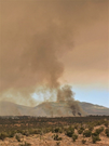
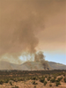
BANDLasConchasFire2_LTrader2011.jpg
A cloud of brown-gray smoke covers the sky over the mountains and the shrub-covered mesas
Smoke clouds created by the Las Conchas Fire in Bandelier
Laura Trader, NPS (2011)
Laura Trader, NPS (2011)
All Rights Reserved:Full Granting Rights:Laura Trader, NPS (2011)
Pueblo and Four Winds Fire Ecology Program
Image
Bandelier National Monument, Code: BAND
Bandelier National Monument, New Mexico
Latitude: 35.8187789916992, Longitude: -106.357299804688
Latitude: 35.8187789916992, Longitude: -106.357299804688
01/01/2011
01/01/0001
Public Can View
Organization: Pueblo and Four Winds Fire Ecology
Friday, May 23, 2025 6:07:06 PM
Friday, May 23, 2025 6:32:23 PM
BANDLasConchasFire2_LTrader2011.jpg
Monday, January 1, 0001 12:00:00 AM
jpg
70.3 kB
Scenic
,
Events