Select Item below to DOWNLOAD - Once item is selected, right click and choose 'save as'
a8f65516-18cd-45d1-b37d-7aa8a7ca1653
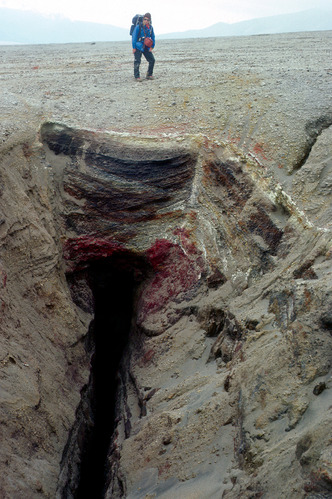
Fumarole
Photograph of an inactive fumarolic fissure.
. Photograph of an inactive fumarolic fissure.
This fumarole formed along a fracture that is near the
edges of the ignimbrite (see Figure 20). Deposits at the
top of fissure are windblown accumulations of pumice,
with colorful alteration from steam and hot gases that
deposited their dissolved minerals in and around the
pieces of pumice. When this photograph was taken in
1982, a weak vapor plume was still coming through this
fumarole, but it is now filled in by windblown pumice
and ash.
Permission must be secured from the individual copyright owners to reproduce any copyrighted materials contained within this website. Digital assets without any copyright restrictions are public domain.
USGS-CalVO photograph by Wes Hildreth.
Public domain:Full Granting Rights
Image
Alagnak Wild River, Code: ALAG
Katmai National Park and Preserve, Code: KATM
Katmai National Park and Preserve, Code: KATM
Alagnak Wild River, Lake and Peninsula Borough, Alaska
Latitude: 59.003101348877, Longitude: -156.082000732422
Katmai National Park and Preserve, Alaska
Latitude: 58.5661087036133, Longitude: -154.889404296875
Latitude: 59.003101348877, Longitude: -156.082000732422
Katmai National Park and Preserve, Alaska
Latitude: 58.5661087036133, Longitude: -154.889404296875
09/23/2016
09/23/2016
Public Can View
Thursday, September 2, 2021 12:43:15 PM
Thursday, September 2, 2021 2:55:47 PM
19_KATM_Fig. 8b-fumarole.jpg
Friday, September 23, 2016 2:08:58 PM
jpg
2.1 MB
Scenic