Select Item below to DOWNLOAD - Once item is selected, right click and choose 'save as'
a8b4effa-7b8b-441d-b7b0-f0387352f7ed
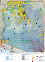
Map of Active Faults, Earthquakes, and Seismograph Stations in Arizona
Map of active faults, earthquakes, and seismograph stations in Arizona.
Each year hundreds of unfelt and several felt earthquakes are recorded in Arizona. These earthquakes generally occur within a swath from the north-northwestern to the southeastern part of the state. The
Yuma area (southwestern corner of the state) also has earthquakes. Most earthquake activity is located within 8–16 km (5–10 mi) of known faults. The closest active faults to the monument are approximately
100 km (60 mi) to the west (near Gila Bend) and about 90 km (60 mi) to the east (near Mammoth). This map also delineates Modified Mercalli Scale intensities of the 1887 Sonoran earthquake, 1940 Imperial
Valley earthquake in southern California (felt in the Yuma area), and three magnitude 6 earthquakes in the early 1900s, which caused damage in the Flagstaff–Grand Canyon region. These show that the state has been subject to intensities of up to IX.
Permission must be secured from the individual copyright owners to reproduce any copyrighted materials contained within this website. Digital assets without any copyright restrictions are public domain.
Graphic by Trista Thornberry-Ehrlich (Colorado State University) using AZGS graphics and data available at http://azgs.arizona.edu/center-natural-hazards/earthquakes,
http://data.azgs.az.gov/hazard-viewer/, and http://www.azgs.az.gov/eq_monitor.shtml (acce
Public domain:Full Granting Rights
Image
Casa Grande Ruins National Monument, Code: CAGR
Casa Grande Ruins National Monument, Pinal County, Arizona
Latitude: 32.996898651123, Longitude: -111.532997131348
Latitude: 32.996898651123, Longitude: -111.532997131348
01/01/0001
Public Can View
Wednesday, July 21, 2021 2:09:33 PM
Wednesday, July 21, 2021 2:41:57 PM
Figure_14_CAGR_Earthquakes_0420-2018_tte-01.jpg
Monday, January 1, 0001 12:00:00 AM
jpg
2.5 MB
Scenic