Select Item below to DOWNLOAD - Once item is selected, right click and choose 'save as'
a42f7b7c-2b43-4319-9734-d746596902b3
Oliver Jackson FINAL PROOF 002
Scanned image of a Homestead final proof form. See description for text.
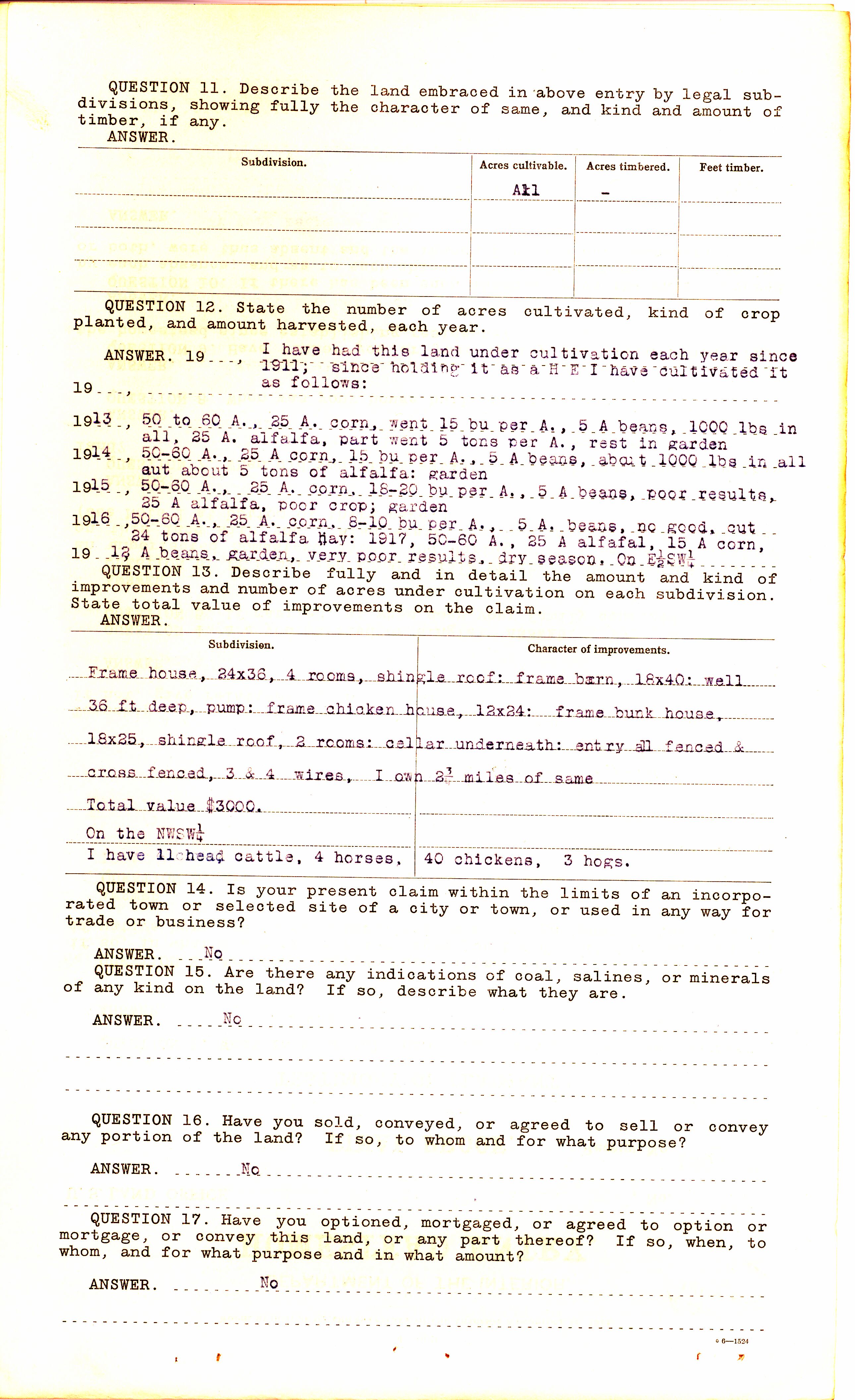
Question 11. Describe the land embraced in above entry by legal subdivisions, showing fully the character of same, and kind and amount of timber, if any.
Answer [Chart Form]
Subdivision -
Acres cultivable – All
Acres timbered -
Feet Timber -
Question 12. State the number of acres cultivated, kind of crop planted, and amount harvested, each year.
Answer 19--, I have had this land uner cultivation each year since 1911; since holding it as a H E I have cultivated it as follows:
1913, 50 to 60 A. 25 A. corn, went 15 bu per A., 5 A beans, 1000 lbs in all, 25 A. alfalfa, part went 5 tons per A., rest in garden
1914, 50-60 A., 25 A corn, 15 bu per A., 5 A beans, about 1000lbs in all out about 5 tons of alfalfa: garden
1915, 50-60 A., 25 A. corn. 18-20 bu per A., 5 A beans, poor results, 25 A alfalfa, poor crop; garden
1916, 50-60 A., 25 A. corn, 8-10 bu per A., beans, no good, cut 24 tons of alfalfa
May: 1917, 50-60 A., 25 A alfafal, 15 A corn, 12 A beans, garden, very poor results, dry season. On E1/2SW1/4
Question 13. Describe fully and in detail the amount and kind of improvements and number of acres under cultivation on each subdivision. State total value of improvements on the claim.
Answer [divided in columns] Subdivision, Character of improvements
Frame house, 24x36, 4rooms, shingle roof; frame barn, 18x40: well 36 ft deep, pump: frame chicken house, 12x24: frame bunk house, 18x25, shingle roof, 2 rooms: cellar underneath: entry all fenced and cross fenced, 3 & 4 wires, I own 2 ¾ miles of same
Total value $3000.
On the NWSW ¼
I have 11 head cattle, 4 horses, 40 chickens, 3 hogs.
QUESTION 14. Is your present claim within the limits of an incorporated town or selected site of a city or town, or used in any way for trade or business
Answer. No
QUESTION 15. Are there any indications of coal, salines, or minerals of any kind on the land? If so, describe what they are.
Answer. No
QUESTION 16. Have you sold, conveyed, or agreed to sell or convey any portion of the land? If so, to whom and for what purpose?
Answer. No
QUESTION 17. Have you optioned, Mortgaged, or agreed to option or mortgage, or convey this land, or any part thereof? If so, when, to whom, and for what purpose and in what amount?
Answer. No
C6-1524
Federal records are public domain
National Archives and Records Administration
Public domain:Full Granting Rights
Document
Homestead National Historical Park, Code: HOME
Homestead National Historical Park, Gage County, Nebraska
Latitude: 40.2879981994629, Longitude: -96.8339004516602
Latitude: 40.2879981994629, Longitude: -96.8339004516602
Unknown
01/01/0001
Land Entry Case Files: Homestead Final Certificates. Record Group 49: Records of the Bureau of Land Management. National Archives and Records Administration.
Public Can View
Organization: Homestead National Historical Park
Address: 8523 W State Hwy 4, Beatrice, NE 68310
Email: home_information@nps.gov
Address: 8523 W State Hwy 4, Beatrice, NE 68310
Email: home_information@nps.gov
Tuesday, April 13, 2021 10:07:19 AM
Thursday, July 17, 2025 6:47:10 PM
Oliver Jackson FINAL PROOF 002.tif
Monday, January 1, 0001 12:00:00 AM
tif
43.6 MB
Historic