Select Item below to DOWNLOAD - Once item is selected, right click and choose 'save as'
a3cbb8f2-5f42-445d-88d5-c6d31a5c48fc
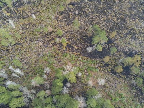
Aerial View
Aerial view of the burn area, showing a mosaic pattern of burn scars
This drone, flown by the fire crew, gives them an overhead view of the burn area. The mosaic pattern of burning is intended to mimic a natural fire that slowly creeps through the forest.
Permission must be secured from the individual copyright owners to reproduce any copyrighted materials contained within this website. Digital assets without any copyright restrictions are public domain.
NPS Photo
Public domain:Full Granting Rights
Image
Big Thicket National Preserve, Code: BITH
Latitude: 30.6502046769722, Longitude: -94.6741829305833, Elevation: 176.402618408203
Big Thicket National Preserve, Texas
Latitude: 30.1642608642578, Longitude: -94.3181228637695
Big Thicket National Preserve, Texas
Latitude: 30.1642608642578, Longitude: -94.3181228637695
02/05/2021
02/05/2021
Public Can View
Tuesday, June 7, 2022 4:52:55 PM
Tuesday, June 7, 2022 5:10:12 PM
P1290129.JPG
Parrot Parrot, AnafiThermal
8333/1000000 sec at f / 2.4
4 mm
ISO 107
Friday, February 5, 2021 4:00:40 PM
jpg
4.9 MB
Scenic