Select Item below to DOWNLOAD - Once item is selected, right click and choose 'save as'
94ebdf89-5b4b-44f8-9d12-0a69bf4a80bf
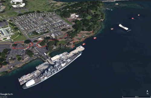
2018 Cultural Landscape Inventory Boundary (CPO Bungalows Neighborhood and Battleship Row)
Aerial view of the shoreline at Pearl Harbor. The cultural landscape boundary is near the shore
where a battleship is docked along a pier, shown using a red outline in the photo.
View looking north from an altitude of 1,264 feet toward the site. The red lines denote the site boundary.
Permission must be secured from the individual copyright owners to reproduce any copyrighted materials contained within this website. Digital assets without any copyright restrictions are public domain.
Google Earth (NPS annotation)
Public domain:Full Granting Rights
Image
Pearl Harbor National Memorial, Code: PERL
Park Cultural Landscapes Program, Code: PCLP
Park Cultural Landscapes Program, Code: PCLP
Latitude: 21.3675937652588, Longitude: -157.938568115234
2018
Public Can View
Person: Vida Germano
Email: vida_germano@nps.gov
Email: vida_germano@nps.gov
Wednesday, February 3, 2021 4:17:09 PM
Wednesday, February 3, 2021 4:17:09 PM
2018 CLI Boundary.png
png
1.5 MB
Scenic