Select Item below to DOWNLOAD - Once item is selected, right click and choose 'save as'
936f4ea5-ce0b-4dd0-87af-78a1f2b25fd2
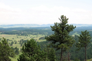
Rankin Ridge Wind Cave National Park
Rankin Ridge - View from fire tower
Climbs through ponderosa pine forest to Rankin Ridge Fire Tower which offers 360 panoramic view of Black Hills and surrounding plains.
U.S. National Park Service
IN COPYRIGHT. This Item is protected by copyright and/or related rights. Copyright: Jim Walla
Jim Walla
Restrictions apply on use and/or reproduction:Copyrighted material
Image
National Trails System, Code: NTS
Wind Cave National Park, Code: WICA
Wind Cave National Park, Code: WICA
At Wind Cave Nat. Park on US 385 between Hot Springs and Pringle.
Wind Cave National Park, Custer County, South Dakota
Latitude: 43.5802993774414, Longitude: -103.439002990723
Wind Cave National Park, Custer County, South Dakota
Latitude: 43.5802993774414, Longitude: -103.439002990723
7/16/2018 12:00:00 AM
12/29/2021
Public Can View
Person: Jim Walla
Organization: Wind Cave National Park
Address: Hot Springs, SD
Organization: Wind Cave National Park
Address: Hot Springs, SD
Thursday, May 12, 2022 7:31:14 PM
Thursday, May 12, 2022 7:31:14 PM
Rankin Ridge 4.jpg
jpg
91.0 kB
Scenic