Select Item below to DOWNLOAD - Once item is selected, right click and choose 'save as'
8e9cbcce-33d7-4001-a03b-618fc7d3e6cf
Testimony of Witness, John Carter, page 2
Scanned image of form. See description for text.
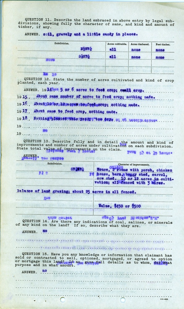
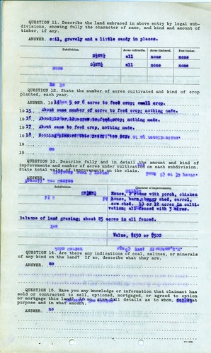
QUESTION 11. Describe the land embraced in above entry by legal subdivisions, showing fully the character of same, and kind and amount of timber, if any.
ANSWER. soil, gravely and a little sandy in places.
Subdivision. Acres cultivable. Acres timbered. Feet timber.
N ½ NE ¼ all none none
S ½ NE ¼ all none none
QUESTION 12. State the number of acres cultivated and kind of crop planted each year.
ANSWER. 1914, 5 or 6 acres to feed crop; small crop.
1915, About same number of acres to feed crop; nothing made.
1916, About 10 or 12 acres to feed crop; nothing made.
1917, About same to feed crop, nothing made.
1918, Nothing planted this year; too dry.
QUESTION 13. Describe fully and in detail the amount and kind of improvements and number of acres under cultivation on each subdivision. State total value of improvements on the claim.
ANSWER.
Subdivision. Character of Improvements.
SE ¼ NE ¼ House, 2 rooms with porch, chicken house, barn, buggy shed, carrol [sic], cow shed. 10 or 12 acres in cultivation; all fenced with 3 wires.
Balance of land grazing; about 25 acres in all fenced.
Value, $450 or $500
QUESTION 14. Are there any indications of coal, salines, or minerals of any kind on the land? If so, describe what they are.
ANSWER. no
QUESTION 15. Have you any knowledge or information that claimant has sold or contracted to sell, optioned, mortgaged, or agreed to option or mortgage this land? If so, give full details as to whom, for what purpose and in what amount.
ANSWER. no
o 6—4320
Federal records are in the public domain
Public domain
Document
Homestead National Historical Park, Code: HOME
Chaves County, New Mexico
Latitude: 40.2879981994629, Longitude: -96.8339004516602
Latitude: 40.2879981994629, Longitude: -96.8339004516602
unknown
01/01/1914 - 12/30/1919
Land Entry Case Files: Homestead Final Certificates. Record Group 49: Records of the Bureau of Land Management. National Archives and Records Administration.
Public Can View
Organization: Homestead National Historical Park
Address: 8523 W State Hwy 4, Beatrice, NE 68310
Address: 8523 W State Hwy 4, Beatrice, NE 68310
Wednesday, September 8, 2021 8:42:00 AM
Thursday, July 17, 2025 7:23:16 PM
RG49.B29242.F821254.17.tif
Monday, January 1, 0001 12:00:00 AM
tif
42.2 MB
Historic