Select Item below to DOWNLOAD - Once item is selected, right click and choose 'save as'
8d54311e-c5da-49f0-b9ac-92eda1be4733
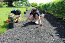
Xiony and Tori Measuring Plant Spacing
Two people work in a mulched garden bed, using a measuring tape to space out planting locations. One person holds a potted rose bush, while the other places a small orange flag to mark the spot. More potted plants and flags are visible in the background.
Two crew members measure planting distances for a landscaping project at the Charlestown Navy Yard.
Permission must be secured from the individual copyright owners to reproduce any copyrighted materials contained within this website. Digital assets without any copyright restrictions are public domain.
NPS
Public domain:Full Granting Rights
Image
Boston National Historical Park, Code: BOST
Boston African American National Historic Site, Code: BOAF
Boston Harbor Islands National Recreation Area, Code: BOHA
Boston African American National Historic Site, Code: BOAF
Boston Harbor Islands National Recreation Area, Code: BOHA
Boston National Historical Park, Suffolk County, Massachusetts
Latitude: 42.3734016418457, Longitude: -71.0557022094727
Boston African American National Historic Site, Suffolk County, Massachusetts
Latitude: 42.3578987121582, Longitude: -71.0706024169922
Boston Harbor Islands National Recreation Area, Massachusetts
Latitude: 42.2621994018555, Longitude: -70.8761825561523
12/03/2016
12/03/2016
Public Can View
Tuesday, August 26, 2025 7:13:40 PM
Wednesday, August 27, 2025 12:28:40 PM
Xiony and Tori Measuring Plant Spacing.jpg
Saturday, December 3, 2016 3:27:46 PM
jpg
2.1 MB
Scenic