Select Item below to DOWNLOAD - Once item is selected, right click and choose 'save as'
8ab3edc7-685f-470d-bd5f-183e8a590e72
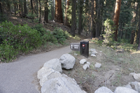
Sunset Rock Trail
An asphalt path leads into a grove of trees.
The view of the start of Sunset rock trail.
Permission must be secured from the individual copyright owners to reproduce any copyrighted materials contained within this website. Digital assets without any copyright restrictions are public domain.
Public domain:Full Granting Rights
Image
Sequoia and Kings Canyon National Parks, Code: SEKI
Latitude: 36.565625, Longitude: -118.772348, Elevation: 1953.55376344086
Sequoia and Kings Canyon National Parks, California
Latitude: 36.7172584533691, Longitude: -118.537902832031
Sequoia and Kings Canyon National Parks, California
Latitude: 36.7172584533691, Longitude: -118.537902832031
08/03/2016
08/03/2016
Public Can View
Wednesday, January 27, 2021 12:06:31 PM
Wednesday, January 27, 2021 12:06:31 PM
SEQU_CB-HCF_160803_sunsetrocktrailsign.JPG
SONY SONY, ILCE-6300 640, E PZ 16-50mm F3.5-5.6 OSS
1/160 sec at f / 4
16 mm
ISO 640
Thursday, August 4, 2016 3:05:04 AM
jpg
19.5 MB
Scenic