Select Item below to DOWNLOAD - Once item is selected, right click and choose 'save as'
8a101f98-bba3-4df2-9b0b-9def4d2aa6dc
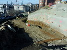
Southwest staircase view before micropiles.
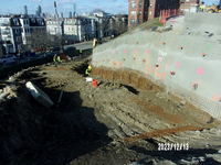
View looking downhill at a gravel path against a steep rising knoll to the right. Knoll is covered with grey sprayed concrete.
Steel mesh and smaller rebar pilings are installed on the hill side and then covered with sprayed concrete. This stabilizes the face of the hillside and forms a foundation for the eventual poured retaining walls.
Permission must be secured from the individual copyright owners to reproduce any copyrighted materials contained within this website. Digital assets without any copyright restrictions are public domain.
All Rights Reserved:Full Granting Rights:Procon Consulting for the National Park Service.
Image
Boston National Historical Park, Code: BOST
Boston National Historical Park, Suffolk County, Massachusetts
Latitude: 42.3734016418457, Longitude: -71.0557022094727
Latitude: 42.3734016418457, Longitude: -71.0557022094727
12/13/2023
12/13/2023
Public Can View
Person: Boston National Historical Park
Organization: BOST
Organization: BOST
Thursday, April 4, 2024 2:50:29 PM
Thursday, April 4, 2024 3:21:42 PM
100_8386.JPG
JK Imaging, Ltd. JK Imaging, Ltd., KODAK PIXPRO FZ53
10/1100 sec at f / 10.8
5.1 mm
ISO 80
Wednesday, December 13, 2023 12:27:54 PM
jpg
2.8 MB
Monitoring