Select Item below to DOWNLOAD - Once item is selected, right click and choose 'save as'
7cf59ee8-685a-4a2d-9ca8-df14736d29c2
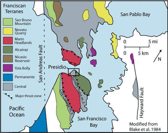
Franciscan Complex Tectonic Terranes
Map of Franciscan Complex tectonic terranes.
Map of Franciscan Complex tectonic terranes.
This map shows the seven terranes of the Franciscan
complex which are mapped in the park and the mélange
(“Central terrane”) that separates them. Each terrane
represents a period of accretion and is characterized
by a specific history of rock deposition and degree of
metamorphism.
Permission must be secured from the individual copyright owners to reproduce any copyrighted materials contained within this website. Digital assets without any copyright restrictions are public domain.
Graphic modified by Will Elder (National
Park Service) from Blake et al. (1984)
Public domain:Full Granting Rights
Image
Fort Point National Historic Site, Code: FOPO
Golden Gate National Recreation Area, Code: GOGA
Muir Woods National Monument, Code: MUWO
Golden Gate National Recreation Area, Code: GOGA
Muir Woods National Monument, Code: MUWO
Fort Point National Historic Site, San Francisco County, California
Latitude: 37.8084983825684, Longitude: -122.473999023438
Golden Gate National Recreation Area, California
Latitude: 37.8916893005371, Longitude: -122.635803222656
Muir Woods National Monument, Marin County, California
Latitude: 37.8983993530273, Longitude: -122.583999633789
Latitude: 37.8084983825684, Longitude: -122.473999023438
Golden Gate National Recreation Area, California
Latitude: 37.8916893005371, Longitude: -122.635803222656
Muir Woods National Monument, Marin County, California
Latitude: 37.8983993530273, Longitude: -122.583999633789
Public Can View
Monday, September 6, 2021 9:30:50 AM
Monday, September 6, 2021 10:39:08 AM
17_terrane-map_1.gif
gif
29.3 kB
Scenic