Select Item below to DOWNLOAD - Once item is selected, right click and choose 'save as'
7c0e0954-5914-49fd-bdb5-9f7666a26fe8
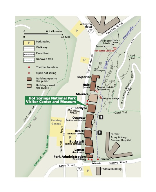
Bathhouse Row Map - Hot Springs National Park
Detail map of Bathhouse National Row in Hot Springs National Park in Arkansas. A column of brown buildings lines one side of Central Avenue, which almost spans the height of the map. Areas to each side are green.
Screen-viewable file; Adobe print production files can be downloaded from the Compressed zip Version link
Map Projection: Other; Map Type: unassigned
U.S. National Park Service
The National Park Service maps are government produced and are in the public domain. Anyone may, without restriction under U.S. copyright laws: Reproduce the work in print or digital form; Create derivative works; Perform the work publicly; Display the work; Distribute copies or digitally transfer the work to the public by sale or other transfer of ownership, or by rental, lease, or lending. Please note, a user who modifies and/or republishes National Park Service maps are responsible for any problems encountered with the maps, due to their change or modification.
Public domain
Document
Hot Springs National Park, Code: HOSP
Hot Springs National Park, Garland County, Arkansas
Latitude: 34.511100769043, Longitude: -93.0896987915039
Latitude: 34.511100769043, Longitude: -93.0896987915039
2021-01-26
Public Can View
Person: Harpers Ferry Center
Organization: US National Park Service
Address: Harpers Ferry Center, Harpers Ferry, WV
Email: HFC_Cartography@nps.gov
Organization: US National Park Service
Address: Harpers Ferry Center, Harpers Ferry, WV
Email: HFC_Cartography@nps.gov
Tuesday, April 26, 2022 9:28:28 PM
Friday, September 26, 2025 11:35:51 PM
HOSPmap3.pdf
pdf
525.6 kB
Map