Select Item below to DOWNLOAD - Once item is selected, right click and choose 'save as'
78e959c0-e78c-4080-9fa8-32e62120ff25
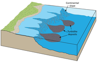
Turbidite Formation
Illustration of turbidite formation.
Illustration of turbidite formation. Turbidites
form when terrestrial sediments tumble from the top of
the steep continental slope into deep water in a densitydriven underwater landslide. Turbidites would eventually
lithify into the graywacke and shale of the Franciscan
Complex. Turbidites typically display a fining-upward
sequence known as graded bedding.
Permission must be secured from the individual copyright owners to reproduce any copyrighted materials contained within this website. Digital assets without any copyright restrictions are public domain.
Graphic by the author
after Tarbuck et al. (2011).
Public domain:Full Granting Rights
Image
Fort Point National Historic Site, Code: FOPO
Golden Gate National Recreation Area, Code: GOGA
Muir Woods National Monument, Code: MUWO
Golden Gate National Recreation Area, Code: GOGA
Muir Woods National Monument, Code: MUWO
Fort Point National Historic Site, San Francisco County, California
Latitude: 37.8084983825684, Longitude: -122.473999023438
Golden Gate National Recreation Area, California
Latitude: 37.8916893005371, Longitude: -122.635803222656
Muir Woods National Monument, Marin County, California
Latitude: 37.8983993530273, Longitude: -122.583999633789
Latitude: 37.8084983825684, Longitude: -122.473999023438
Golden Gate National Recreation Area, California
Latitude: 37.8916893005371, Longitude: -122.635803222656
Muir Woods National Monument, Marin County, California
Latitude: 37.8983993530273, Longitude: -122.583999633789
01/01/0001
Public Can View
Monday, September 6, 2021 9:30:09 AM
Monday, September 6, 2021 10:39:08 AM
12_GOGA_Turbidites-01.jpg
Monday, January 1, 0001 12:00:00 AM
jpg
800.2 kB
Scenic