Select Item below to DOWNLOAD - Once item is selected, right click and choose 'save as'
7879a5b3-6440-4ef2-a984-7ad2d1dda1a3
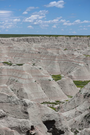
Big Badlands Overlook
formations capped with green prairie containing reddish-orange rock layers
The layers of the Badlands represent past environments in geologic time. The environment represented by the Brule Formation, seen here, would have been a cool, dry grassland much like the Great Plains are today.
Permission must be secured from the individual copyright owners to reproduce any copyrighted materials contained within this website. Digital assets without any copyright restrictions are public domain.
NPS / Ed Welsh
Public domain:Full Granting Rights
Image
Badlands National Park, Code: BADL
Badlands National Park, South Dakota
Latitude: 43.8339996337891, Longitude: -102.393898010254
Latitude: 43.8339996337891, Longitude: -102.393898010254
01/01/0001
Public Can View
Friday, April 24, 2020 11:21:39 AM
Friday, April 24, 2020 11:21:39 AM
thumbnail (6).jpg
Monday, January 1, 0001 12:00:00 AM
jpg
117.5 kB
Scenic