Select Item below to DOWNLOAD - Once item is selected, right click and choose 'save as'
76cee49a-8044-490a-842f-66a7567acc71
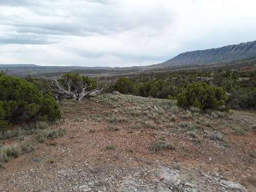
BICA_LTM_Veg040_PP01_2023_S.jpg
Photo of the landscape and upland vegetation in Bighorn Canyon National Recreation Area.
Permission must be secured from the individual copyright owners to reproduce any copyrighted materials contained within this website. Digital assets without any copyright restrictions are public domain.
Public domain
Image
Greater Yellowstone Network, Code: GRYN
Bighorn Canyon National Recreation Area, Code: BICA
Bighorn Canyon National Recreation Area, Code: BICA
Latitude: 45.1195324027778, Longitude: -108.245719083333, Elevation: 1328.75
Bighorn Canyon National Recreation Area
Latitude: 45.2888603210449, Longitude: -108.027099609375
Bighorn Canyon National Recreation Area
Latitude: 45.2888603210449, Longitude: -108.027099609375
05/31/2023
05/31/2023
Public Can View
Person: Rob Daley
Organization: NPS Greater Yellowstone Inventory and Monitoring Network
Role: Data Manager
Position: Data Manager
Address: Bozeman Montana
Email: Rob_Daley@nps.gov
Organization: NPS Greater Yellowstone Inventory and Monitoring Network
Role: Data Manager
Position: Data Manager
Address: Bozeman Montana
Email: Rob_Daley@nps.gov
Tuesday, September 24, 2024 11:20:59 PM
Friday, October 4, 2024 1:55:13 PM
BICA_LTM_Veg040_PP01_2023_S.jpg
samsung samsung, SM-T390
1/641 sec at f / 1.9
2.91 mm
ISO 40
Wednesday, May 31, 2023 4:45:14 PM
jpg
1.1 MB
Scenic
,
Monitoring