Select Item below to DOWNLOAD - Once item is selected, right click and choose 'save as'
742a88c3d7df4f3aa429e32c438f65a6
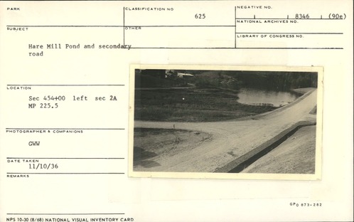
Hare Mill Pond and secondary road
Hare Mill Pond and secondary road
Section 2-A, Station 454+00 left, Milepost 225.5
U.S. National Park Service
Permission must be secured from the individual copyright owners to reproduce any copyrighted materials contained within this website.
GWW
Public domain
Image
Blue Ridge Parkway, Code: BLRI
Milepost 225, Blue Ridge Parkway
Blue Ridge Parkway
Latitude: 36.4365005493164, Longitude: -81.070556640625
Blue Ridge Parkway
Latitude: 36.4365005493164, Longitude: -81.070556640625
November 10, 1936
11/10/1936
Public Can View
Organization: US National Park Service
Role: Museum Curator
Address: Blue Ridge Parkway Headquarters
Email: blri_info@nps.gov
Role: Museum Curator
Address: Blue Ridge Parkway Headquarters
Email: blri_info@nps.gov
Thursday, February 13, 2020 11:46:29 AM
Thursday, February 13, 2020 11:46:29 AM
0019_MP225_1.tif
tif
10.9 MB
Scenic
,
Historic