Select Item below to DOWNLOAD - Once item is selected, right click and choose 'save as'
7115d431-3fbe-4015-aa7d-a9c49699e5d7
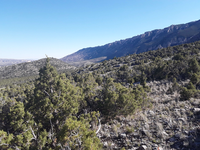
BICA_LTM_Veg050_PP01_2021_S.jpg
Image of the vegetation and landscape at photo point in Bighorn Canyon NRA.
Permission must be secured from the individual copyright owners to reproduce any copyrighted materials contained within this website. Digital assets without any copyright restrictions are public domain.
Public domain
Image
Greater Yellowstone Network, Code: GRYN
Bighorn Canyon National Recreation Area, Code: BICA
Bighorn Canyon National Recreation Area, Code: BICA
Latitude: 45.1031033055556, Longitude: -108.277803861111, Elevation: 1527.282
Bighorn Canyon National Recreation Area
Latitude: 45.2888603210449, Longitude: -108.027099609375
Bighorn Canyon National Recreation Area
Latitude: 45.2888603210449, Longitude: -108.027099609375
06/02/2021
06/02/2021
Public Can View
Person: Rob Daley
Organization: NPS GRYN
Role: Data Manager
Email: rob_daley@nps.gov
Person: Arista Regalia
Organization: NPS IMR
Role: GIS Assistant
Email: arista_regalia@partner.nps.gov
Organization: NPS GRYN
Role: Data Manager
Email: rob_daley@nps.gov
Person: Arista Regalia
Organization: NPS IMR
Role: GIS Assistant
Email: arista_regalia@partner.nps.gov
Thursday, June 29, 2023 8:15:12 PM
Thursday, June 29, 2023 8:51:22 PM
BICA_LTM_Veg050_PP01_2021_S.jpg
samsung samsung, SM-T390
1/998 sec at f / 1.9
2.91 mm
ISO 40
Wednesday, June 2, 2021 5:44:55 PM
jpg
1.5 MB
Scenic
,
Monitoring