Select Item below to DOWNLOAD - Once item is selected, right click and choose 'save as'
70E6BCA0-1DD8-B71B-0B1026BCE1B41136
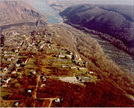
1974 Aerial Photograph of Camp Hill
Aerial view shows sloping land between two rivers, dotted with buildings, trees, and roads.
This aerial photograph taken in 1974 shows the spatial organization of the former Storer College Campus with buildings, parking lots, drives, walks, and vegetation.
U.S. National Park Service
Permission must be secured from the individual copyright owners to reproduce any copyrighted materials contained within this website. Digital assets without any copyright restrictions are public domain.
NPS, Courtesy Harpers Ferry National Historical Park Archives (in 2009 Camp Hill Cultural Landscape Report)
Public domain:Full Granting Rights
Image
Harpers Ferry National Historical Park, Code: HAFE
Harpers Ferry National Historical Park
Latitude: 39.312858581543, Longitude: -77.7419586181641
Public Can View
Wednesday, September 12, 2018 3:05:41 PM
Wednesday, September 12, 2018 3:05:41 PM
70E7EA8D-1DD8-B71B-0B163582A0D6554E.jpg
Monday, January 1, 0001 12:00:00 AM
jpg
444.2 kB
Scenic