Select Item below to DOWNLOAD - Once item is selected, right click and choose 'save as'
6bf1cfc1-52d8-4307-9a79-9b7eadf02a74
Cross-Section
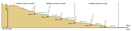
Cross-sectional topographic view of the marine terraces (green text) and paleoshorelines (brown text) of the North Carolina Coastal Plain. The cross section includes 6 terraces and 6 paleoshoreline locations. The 6 terraces are in ascending order, Pamilico, Talbot, Wicomico, Sunderland, Coharie, and Brandywine. These are separated by the 6 shorelines in ascending order, Suffolk, Walterboro, Surry, Kenly, Wilson Mills, and Coats.
Cross-sectional topographic view of the marine terraces (green text) and paleoshorelines (brown text) of the North Carolina Coastal Plain
Permission must be secured from the individual copyright owners to reproduce any copyrighted materials contained within this website. Digital assets without any copyright restrictions are public domain.
Graphic by Trista Thornberry-Ehrlich, modified after figure 3 in Daniels et al. (1984)
Public domain:Full Granting Rights
Image
Cape Lookout National Seashore, Code: CALO
Cape Lookout National Seashore, Carteret County, North Carolina
Latitude: 34.9581985473633, Longitude: -76.1900024414063
Latitude: 34.9581985473633, Longitude: -76.1900024414063
01/01/0001
Public Can View
Thursday, August 5, 2021 10:42:37 AM
Thursday, August 5, 2021 1:02:23 PM
01_CALO_coastalplain_terracesscarps_0717-2017_tte-01.jpg
Monday, January 1, 0001 12:00:00 AM
jpg
2.0 MB
Scenic