Select Item below to DOWNLOAD - Once item is selected, right click and choose 'save as'
697d9358cc874827af7501cee0653cb0
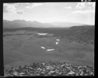
Lower Gaylor Lakes
Lower Gaylor Lakes
Lower Gaylor Lakes
Negative Number: RL_00928
U. S. National Park Service
Permission must be secured from the individual copyright owners to reproduce any copyrighted materials contained within this website.
Public domain
Image
Yosemite National Park, Code: YOSE
Yosemite National Park, California
Latitude: 37.8399200439453, Longitude: -119.540397644043
Latitude: 37.8399200439453, Longitude: -119.540397644043
9/1/1967 12:00:00 AM
09/01/1967
Film Size: 4 x 5
YOSE: Box 59
Public Can View
Person: Archivist
Organization: US National Park Service
Address: Yosemite National Park Archives, PO Box 700-W, El Portal, CA 95318
Email: yose_archives@nps.gov
Organization: US National Park Service
Address: Yosemite National Park Archives, PO Box 700-W, El Portal, CA 95318
Email: yose_archives@nps.gov
Wednesday, July 8, 2020 3:32:59 PM
Wednesday, July 8, 2020 3:32:59 PM
RL_00928.tif
tif
14.3 MB
Museum