Select Item below to DOWNLOAD - Once item is selected, right click and choose 'save as'
663bd20b-83f8-47d4-a109-0eeaf530a5bc
DEWA.3013.DN.2018
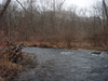
Site visit photo showing the upstream (UP) or downstream (DN) view of a wadeable stream reach taken during benthic macroinvertebrate monitoring at Delaware Water Gap National Recreation Area.
Site visit photo showing the upstream (UP) or downstream (DN) view of a wadeable stream reach taken during benthic macroinvertebrate monitoring at Delaware Water Gap National Recreation Area.
U.S. National Park Service
This digital asset is in the public domain. When using this asset for any purpose, including online, use: Photo Credit: U.S. National Park Service.
Photo Credit: National Park Service
Public domain
Little Bushkill Creek 01 - DEWA.3013, (ERMN Stream Site Name)
, DEWA.3013, (ERMN Stream Site ID)
, DEWA.3013.DN, (ERMN Stream Site Up and Down)
, ERMN Benthic Macroinvertebrate Monitoring, (ERMN Project Name)
, DEWA.3013, (ERMN Stream Site ID)
, DEWA.3013.DN, (ERMN Stream Site Up and Down)
, ERMN Benthic Macroinvertebrate Monitoring, (ERMN Project Name)
Image
Delaware Water Gap National Recreation Area, Code: DEWA
Eastern Rivers and Mountains Network, Code: ERMN
Eastern Rivers and Mountains Network, Code: ERMN
Delaware Water Gap National Recreation Area
Latitude: 41.1003189086914, Longitude: -74.9569320678711
Latitude: 41.1003189086914, Longitude: -74.9569320678711
Title: NPS DataStore Project
URL: https://irma.nps.gov/DataStore/Reference/Profile/2229360
Title: Eastern Rivers and Mountains Network Website
URL: https://www.nps.gov/im/ermn/index.htm
URL: https://irma.nps.gov/DataStore/Reference/Profile/2229360
Title: Eastern Rivers and Mountains Network Website
URL: https://www.nps.gov/im/ermn/index.htm
2018/03/29
01/01/2018 - 12/30/2018
Public Can View
Organization: Eastern Rivers and Mountains Network
Position: Data Manager
Position: Data Manager
Friday, August 9, 2024 3:24:19 PM
Friday, August 9, 2024 3:24:19 PM
DEWA.3013.DN.2018.JPG
jpg
3.3 MB
Monitoring