Select Item below to DOWNLOAD - Once item is selected, right click and choose 'save as'
6345bf19-deb2-4fcc-8a74-269b93b38d5c
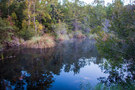
Davis Bayou Area Pond
Davis Bayou Area Pond
Davis Bayou Area Pond
Permission must be secured from the individual copyright owners to reproduce any copyrighted materials contained within this website. Digital assets without any copyright restrictions are public domain.
Public domain:Full Granting Rights
Image
Gulf Islands National Seashore, Code: GUIS
Gulf Islands National Seashore
Latitude: 30.3730602264404, Longitude: -86.9099731445313
Latitude: 30.3730602264404, Longitude: -86.9099731445313
10/23/2019
10/23/2019
Public Can View
Friday, January 24, 2020 10:21:34 AM
Friday, January 24, 2020 10:21:34 AM
102219_DavisBayouSunrise_Breault_01.JPG
Canon Canon, Canon EOS 70D 500, EF-S18-135mm f/3.5-5.6 IS STM
1/30 sec at f / 3.5
18 mm
ISO 500
Wednesday, October 23, 2019 12:13:51 PM
jpg
2.7 MB
Scenic