Select Item below to DOWNLOAD - Once item is selected, right click and choose 'save as'
632c8df3-295c-4f45-882b-6c24247a4ca4
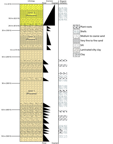
Graphic of Drill Core from Horn Island.
Graphic of drill core from Horn Island showing the different layers of plant root, shells, medium to coarse sand, very fine to fine sand, silt, laminated silty clay, and clay.
Unit 1 (Pliocene Epoch) shows cycles of fining-upward sections with shelly fine sand at the base of each sediment cycle, which were deposited in the channel of an intertidal creek, overlain by clay-silt laminations
deposited as the creek migrated. Bioturbated clays with Rangia bivalve fossils represent a shallow subtidal estuary, and the rooted, oxidized clayey silts represent supratidal flats. The coarser sand section at the
base of Unit 1 probably represents one of the main channels of the estuary. Unit 2 (Pliocene Epoch) consists of cyclic fining-upward sections of noncalcareous sands and clays that were deposited in a river or upper estuarine setting. The fining-upward sand-clay cycles were deposited by migrating streams. Unit
3 (Holocene Epoch) consists of coastal and nearshore-marine sediments. An early Holocene shoreline was established in the vicinity of modern Horn Island approximately 9,500 years ago. The organic marsh and
tidal flat deposits at the base of Unit 3 represent a low-energy part of that shoreline complex. As sea level rose and the shoreline flooded, fine-grained sediments were deposited. A coarsening-upward sequence
records the late Holocene westward migration of Horn Island to its present position. The sandy upper subunit primarily represents the pre-modern subtidal part of Horn Island, which likely includes interbarrier, inlet sediments, and shoreface sediments. The sands above modern sea level at the top of Unit 3 may be mostly aeolian and would now be part of map units Active Dune Complex (dn_cplx_a), Stable/Stabilized Dune Complex (dn_cplx_s), Beach Ridge Complex (bch_rdg_cplx), Vegetated Barrier Flats (veg_
brr_flt), or Vegetated Barrier Core (veg_brr_cr) of the GRI GIS data (see poster, in pocket).
Permission must be secured from the individual copyright owners to reproduce any copyrighted materials contained within this website. Digital assets without any copyright restrictions are public domain.
Graphic by Trista Thornberry-Ehrlich (Colorado State University) after Gohn et al (1996, figure 2).
Public domain:Full Granting Rights
Image
Gulf Islands National Seashore, Code: GUIS
Gulf Islands National Seashore
Latitude: 30.3730602264404, Longitude: -86.9099731445313
Latitude: 30.3730602264404, Longitude: -86.9099731445313
01/01/0001
Public Can View
Monday, June 14, 2021 12:27:07 PM
Monday, June 14, 2021 12:27:07 PM
Figure 36. GUIS_Horn_Core_1209-2016_tte-01.jpg
Monday, January 1, 0001 12:00:00 AM
jpg
4.2 MB
Scenic