Select Item below to DOWNLOAD - Once item is selected, right click and choose 'save as'
5c062bab-cbe5-4235-b955-0db5c174ce3f
VALL
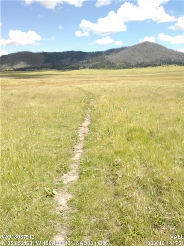
La Jara Hike
Repair Tread/Add Bog Bridges, La Jara Hike
Image with visible watermark of coordinates, FMSS data, date, time and park code.
WO18087913
SURFACE / TRAFSURF
Permission must be secured from the individual copyright owners to reproduce any copyrighted materials contained within this website. Digital assets without any copyright restrictions are public domain.
Public domain
Condition Assessment, (NPS Focus Subject Thesaurus)
, Trails, (NPS Focus Subject Thesaurus)
, FMSS, (NPS Focus Subject Thesaurus)
, Trails, (NPS Focus Subject Thesaurus)
, FMSS, (NPS Focus Subject Thesaurus)
Image
Valles Caldera National Preserve, Code: VALL
New Mexico
Latitude: 35.8521633, Longitude: -106.4980118, Elevation: 2563.2
Latitude: 35.8521633, Longitude: -106.4980118, Elevation: 2563.2
08/30/2016
08/30/2016
Public Can View
Organization: FMGIS
Email: Brian_Diethorn@partner.nps.gov
Organization: FMGIS
Email: Shawn_Wignall@nps.gov
Email: Brian_Diethorn@partner.nps.gov
Organization: FMGIS
Email: Shawn_Wignall@nps.gov
Wednesday, December 14, 2016 1:13:55 PM
Wednesday, August 9, 2017 8:43:46 PM
WO18087913_083016_141751_tag.jpg
Garmin Garmin, Monterra
1674/1000000 sec at f / 2.8
4.6 mm
ISO 60
Wednesday, August 31, 2016 8:17:51 AM
jpg
3.6 MB
Inventory