Select Item below to DOWNLOAD - Once item is selected, right click and choose 'save as'
57d96edc-a510-4c19-9d17-2947f90dd112
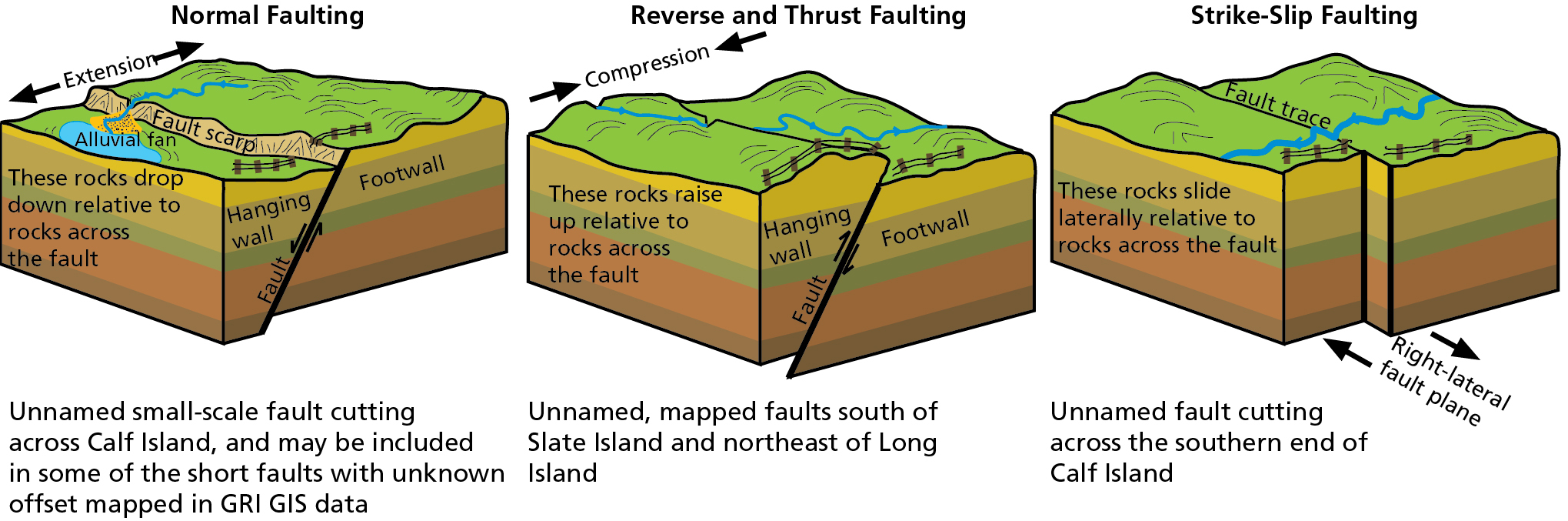
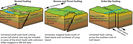
Fault Types
Schematic illustrations of three fault types. Examples of normal faults include Unnamed small-scale fault cutting across Calf Island, and may be included in some of the short faults with unknown offset mapped in GRI GIS data. Reverse or thrust faults include unnamed, mapped faults south of Slate Island and northeast of Long Island. Strike slip faults include an unnamed fault cutting across the southern end of Calf Island.
Schematic illustrations of fault types. Movement occurs along a fault plane. Footwalls are below the fault
plane and hanging walls are above. In a normal fault, crustal extension (pulling apart) moves the hanging wall down
relative to the footwall. In a reverse fault, crustal compression moves the hanging wall up relative to the footwall. A
thrust fault is similar to a reverse fault, but has a dip angle of less than 45°. In a strike-slip fault, the relative direction
of movement of the opposing plate is lateral. When movement across the fault is to the right, it is a right-lateral
fault, as illustrated above. When movement is to the left, it is a left-lateral fault. A strike-slip fault between two plate
boundaries is called a transform fault. Features (e.g., streams and fences) on the surface are intended to demonstrate
the response to the type of fault movement illustrated and is not meant to necessarily reflect features at Boston
Harbor Islands.
Permission must be secured from the individual copyright owners to reproduce any copyrighted materials contained within this website. Digital assets without any copyright restrictions are public domain.
Graphic by Trista Thornberry-Ehrlich (Colorado State University).
Public domain:Full Granting Rights
Image
Boston Harbor Islands National Recreation Area, Code: BOHA
Boston Harbor Islands National Recreation Area, Massachusetts
Latitude: 42.2621994018555, Longitude: -70.8761825561523
Latitude: 42.2621994018555, Longitude: -70.8761825561523
01/01/0001
Public Can View
Monday, August 16, 2021 4:32:04 PM
Monday, August 16, 2021 5:17:19 PM
27_BOHA_faults_2_column (1)_0628-2016_tte-01.jpg
Monday, January 1, 0001 12:00:00 AM
jpg
658.8 kB
Scenic