Select Item below to DOWNLOAD - Once item is selected, right click and choose 'save as'
52e5e22c-282d-4cb1-a089-1a93c84578dc
Ash Fall
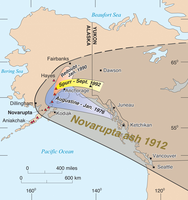
Map of Alaska and adjacent parts of North America showing the location of Novarupta and the region impacted by ash fall.
Map of Alaska and adjacent parts
of North America showing the location of Novarupta
and the region impacted by ash fall. Within a few days
after the 1912 eruption, the ash was carried by winds
across the North American continent. The limited
distribution from other recent Alaska eruptions is
shown for comparison.
Permission must be secured from the individual copyright owners to reproduce any copyrighted materials contained within this website. Digital assets without any copyright restrictions are public domain.
Figure 2 in Fierstein (2012c)
Public domain:Full Granting Rights
Image
Alagnak Wild River, Code: ALAG
Katmai National Park and Preserve, Code: KATM
Katmai National Park and Preserve, Code: KATM
Alagnak Wild River, Lake and Peninsula Borough, Alaska
Latitude: 59.003101348877, Longitude: -156.082000732422
Katmai National Park and Preserve, Alaska
Latitude: 58.5661087036133, Longitude: -154.889404296875
Latitude: 59.003101348877, Longitude: -156.082000732422
Katmai National Park and Preserve, Alaska
Latitude: 58.5661087036133, Longitude: -154.889404296875
09/23/2016
09/23/2016
Public Can View
Thursday, September 2, 2021 12:44:01 PM
Thursday, September 2, 2021 2:55:49 PM
25_KATM_Fig. 1-AK eruptions-comparative areas.jpg
Friday, September 23, 2016 2:14:10 PM
jpg
1.6 MB
Scenic