Select Item below to DOWNLOAD - Once item is selected, right click and choose 'save as'
3cbd3f4d-a5d9-4fb5-a125-e6b04808f6e0
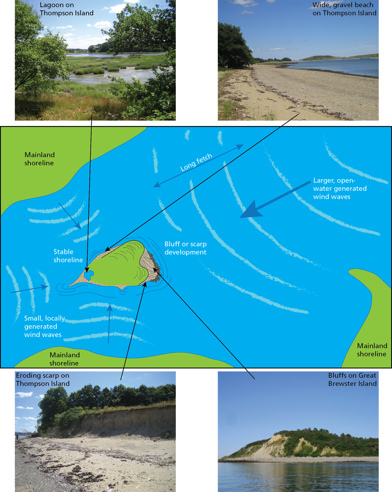
Shoreline Morphologies
Schematic diagram of wave types and shoreline morphologies with accompanying photographs.
Schematic of wave types and shoreline morphologies with accompanying photographs. Waves
reshape the shorelines at Boston Harbor Islands. Where islands are exposed to the longer fetch across the harbor
mouth, larger, higher-energy waves create bluffs and scarps (see fig. 11). Smaller waves refract back from the adjacent
mainland shorelines. These tend to collect sediment as depositional features (e.g., beaches, salients, and spits).
Permission must be secured from the individual copyright owners to reproduce any copyrighted materials contained within this website. Digital assets without any copyright restrictions are public domain.
Photographs (taken in July 2007) and graphic by Trista Thornberry-Ehrlich (Colorado State University) after a figure
presented by Rosen (2007).
Public domain:Full Granting Rights
Image
Boston Harbor Islands National Recreation Area, Code: BOHA
Boston Harbor Islands National Recreation Area, Massachusetts
Latitude: 42.2621994018555, Longitude: -70.8761825561523
Latitude: 42.2621994018555, Longitude: -70.8761825561523
01/01/0001
Public Can View
Monday, August 16, 2021 4:25:40 PM
Monday, August 16, 2021 5:17:18 PM
08_BOHA_Waves_and landforms_Rosen2007_0624-2016_tte.jpg
Monday, January 1, 0001 12:00:00 AM
jpg
2.9 MB
Scenic