Select Item below to DOWNLOAD - Once item is selected, right click and choose 'save as'
3b6c33352f404dc7beae19b2858cbd56
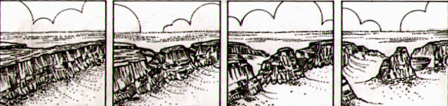
Four-part geologic diagram depicts the creation over time of Independence Monument (l-r):
Four-part geologic diagram depicts the creation over time of Independence Monument (l-r):
1) a massive rock wall between Monument and Wedding Canyons; 2) slowly, as the forces of erosion enlarged these canyons, the dividing wall was narrowed and weakened; 3) weathering and erosion proceeded more rapidly in places where the rock was most vulnerable along natural fractures where, eventually, the wall was breached and parts of it collapsed; 4) today, a remnant of the once solid rock wall survives as Independence Monument, a free-standing monolith.
Abbr=PUB
U.S. National Park Service
Project=Folder; Art_Registration_No=PUB-0020 ; Reflective Art
Government owns art and all reproduction rights.
Public domain
Image
Colorado National Monument, Code: COLM
Colorado National Monument, Mesa County, Colorado
Latitude: 39.0503997802734, Longitude: -108.692001342773
Latitude: 39.0503997802734, Longitude: -108.692001342773
Image Management System : IMS 07212
20190904
01/01/1989 - 12/30/1989
Image_Size=11-3/8" x 3-5/16; Count:2/2; Colorado National Monument park brochure
MC A2
Public Can View
Organization: Harpers Ferry Center
Address: Harpers Ferry Center, 67 Mather Place, Harpers Ferry, WV, 25425, 304-535-5050
Address: Harpers Ferry Center, 67 Mather Place, Harpers Ferry, WV, 25425, 304-535-5050
Monday, October 7, 2019 2:45:42 PM
Monday, October 7, 2019 2:45:42 PM
07212.jpg
jpg
43.3 kB
Museum