Select Item below to DOWNLOAD - Once item is selected, right click and choose 'save as'
2f08b68a-41d3-4aa4-b30d-5a41bf5b7837
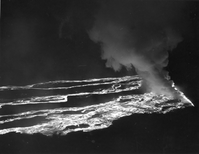
1950 Flows
Black and white aerial photo of lava flows at night
Aerial photo of Mauna Loa lava flows during the 1950 eruption
Permission must be secured from the individual copyright owners to reproduce any copyrighted materials contained within this website. Digital assets without any copyright restrictions are public domain.
NPS Photo/Military Air Transport Service (HAVO 17707 Image Collection; Series V, Box 27, Folder 21, Image 34)
Public domain:Full Granting Rights
Image
Hawaii Volcanoes National Park, Code: HAVO
Hawaii Volcanoes National Park, Hawaii County, Hawaii
Latitude: 19.3775997161865, Longitude: -155.602996826172
Latitude: 19.3775997161865, Longitude: -155.602996826172
01/01/1950
11/13/2020
Public Can View
Sunday, November 15, 2020 12:54:37 AM
Sunday, November 15, 2020 12:54:37 AM
HAVO_1950_Mauna Loa 1950 Eruption_Military Air Transport Service_ 17707_B27_f21_34.jpg
Friday, November 13, 2020 5:34:28 PM
jpg
3.8 MB
Scenic