Select Item below to DOWNLOAD - Once item is selected, right click and choose 'save as'
2e135f09-db6b-4d2b-af65-0cddcae7fe38
Claimant Testimony, page 2
Scanned image of form. See description for text.
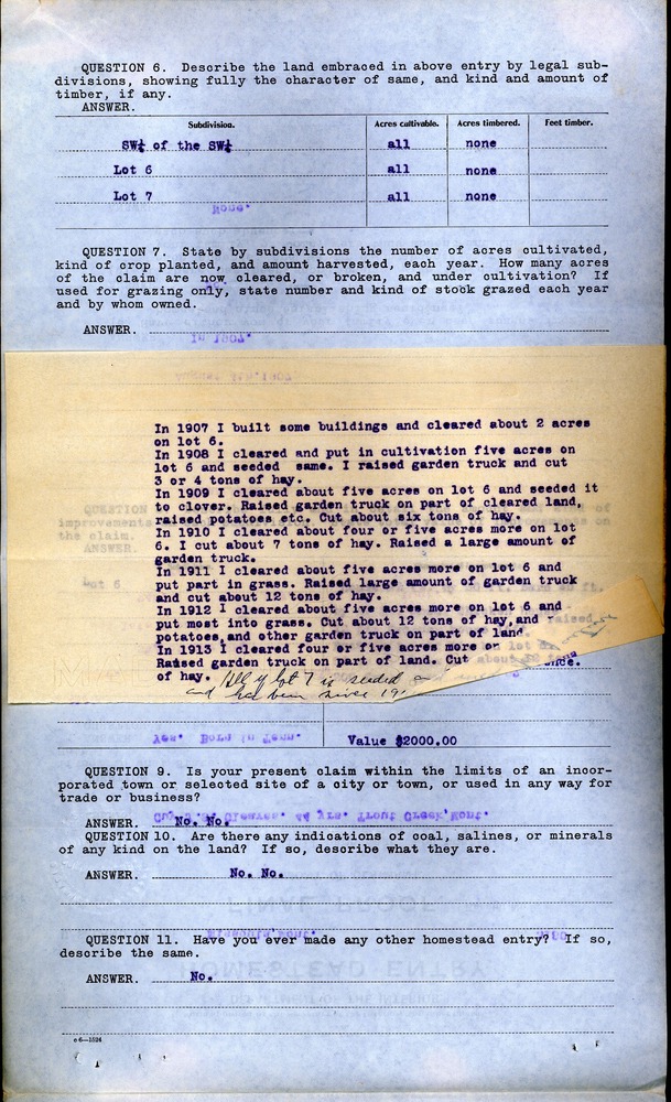
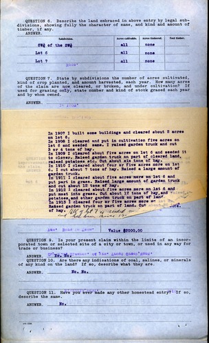
QUESTION 6. Describe the land embraced in above entry by legal subdivisions, showing fully the character of same, and kind and amount of timber, if any.
ANSWER.
Subdivision. Acres cultivable. Acres timbered. Feet timber.
SW ¼ of the SW ¼ all none
Lot 6 all none
Lot 7 all none
QUESTION 7. State by subdivisions the number of acres cultivated, kind of crop planted, and amount harvested, each year. How many acres of the claim are now cleared, or broken, and under cultivation? If used for grazing only, state number and kind of stock grazed each year and by whom owned.
ANSWER.
[attached slip of paper]
In 1907 I built some buildings and cleared about 2 acres on lot 6.
In 1908 I cleared and put in cultivation five acres on lot 6 and seeded same. I raised garden truck and cut 3 or 4 tons of hay.
In 1909 I cleared about five acres on lot 6 and seeded it to clover. Raised garden truck on part of cleared land, raised potatoes etc. Cut about six tons of hay.
In 1910 I cleared about four or five acres more on lot 6. I cut about 7 tons of hay. Raised a large amount of garden truck.
In 1911 I cleared about five acres more on lot 6 and put part in grass. Raised large amount of garden truck and cut about 12 tons of hay.
In 1912 I cleared about five acres more on lot 6 and put most into grass. Cut about 12 tons of hay, and raised potatoes, and other garden truck on part of land.
In 1913 I cleared four or five acres more on lot 6. Raised garden truck on part of land. Cut about 12 tons of hay.
[note] All of lot 7 is seeded and [cut off] and had been since 19[cut off]
[covered by attached paper]
QUESTION 8. Describe fully and in detail the amount and kind of improvements on each subdivision. State total value of improvements on the claim.
ANSWER.
Subdivision. Character of improvements.
Lot 6 House 22 ft. by 30 ft. Barn 40 ft. by 50 ft. Shed. Chicken house 10 ft. 22 ft. Brooder house 16 ft. by 33 ft. Root cellar 16 ft. by 33 ft. 50 or 60 acres under good fence. 200 fruit trees.
Value $2000.00
QUESTION 9. Is your present claim within the limits of an incorporated town or selected site of a city or town, or used in any way for trade or business?
ANSWER. No. No.
QUESTION 10. Are there any indications of coal, salines, or minerals of any kind on the land? If so, describe what they are.
ANSWER. No. No.
[impressed seal] A.S. AINSWORTH UNITED STATES COMMISSIONER DISTRICT OF MONTANA
QUESTION 11. Have you ever made any other homestead entry? If so, describe the same.
ANSWER. No.
c 6—1524
Federal records are in the public domain
Public domain
Document
Homestead National Historical Park, Code: HOME
Sanders County, Montana
Homestead National Historical Park, Gage County, Nebraska
Latitude: 40.2879981994629, Longitude: -96.8339004516602
Homestead National Historical Park, Gage County, Nebraska
Latitude: 40.2879981994629, Longitude: -96.8339004516602
unknown
01/01/1912 - 12/30/1914
Land Entry Case Files: Homestead Final Certificates. Record Group 49: Records of the Bureau of Land Management. National Archives and Records Administration.
Public Can View
Organization: Homestead National Historical Park
Address: 8523 W State Hwy 4, Beatrice, NE 68310
Address: 8523 W State Hwy 4, Beatrice, NE 68310
Tuesday, September 14, 2021 9:41:36 AM
Thursday, July 17, 2025 8:15:28 PM
RG49B14520.430683.2.tif
Monday, January 1, 0001 12:00:00 AM
tif
43.7 MB
Historic