Select Item below to DOWNLOAD - Once item is selected, right click and choose 'save as'
2a2e317e-fd7a-4450-8f96-5904fb4b81f1
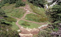
View of site TH4 on Cascade Pass from entry to Pelton Basin, August 2002
A main trail with stairs leading down into a patchy meadow of shrubs, wildflowers, and trees crossed with social trails.
Cascade Pass, Revegetation Site TH4, revegetation monitoring photograph. Text on slide frame reads: "REV/CAS/TH4/a-16, Cascade Pass, View toward Thx 4, 5, 6, 7, Nill C1 from top of steps starting down to Pelton Basin, suspect same or worse damage than 1970, 8 or 9/2002." (North Cascades NPS Complex Museum Collection, NOCA.0013 Revegetation Program Records, Series XI: Photographs, File 001 - Cascade Pass, Vicinity Impacts and Revegetation Sites, 1970-2004)
U.S. National Park Service
This digital asset is in the public domain. When using this asset for any purpose, including online, credit: 'Courtesy of North Cascades NPS Complex Museum Collection, Revegetation Program Records.'
NPS Photo
Public domain
Native Plant Restoration, (North Cascades Program)
, Cascade Pass, (North Cascades Locality)
, Revegetation, (North Cascades Activity)
, Cascade Pass, (North Cascades Locality)
, Revegetation, (North Cascades Activity)
Image
North Cascades National Park, Code: NOCA
North Cascades National Park, Washington
Latitude: 48.8278884887695, Longitude: -121.35050201416
Cascade Pass
Latitude: 48.8278884887695, Longitude: -121.35050201416
Cascade Pass
ICMS Archives Module : NOCA.0013.11.001
2024/01/31
01/01/2002 - 12/30/2002
slide transparency
Curation Facility
Public Can View
Person: NOCA Curator
Organization: North Cascades NPS Complex
Position: Museum Curator
Address: 7280 Ranger Station Road, Marblemount, WA 98267
Email: NOCA_Curator@nps.gov.
Organization: North Cascades NPS Complex
Position: Museum Curator
Address: 7280 Ranger Station Road, Marblemount, WA 98267
Email: NOCA_Curator@nps.gov.
Thursday, January 30, 2025 5:36:06 PM
Thursday, January 30, 2025 5:36:06 PM
0013.11.001.0303.tif
tif
35.3 MB
Monitoring