Select Item below to DOWNLOAD - Once item is selected, right click and choose 'save as'
27b6b666-ec4b-4d5a-b728-d3c830bb20e8
Testimony of Witness, S. Edward Chesnut, page 2
Scanned image of form. See description for text.
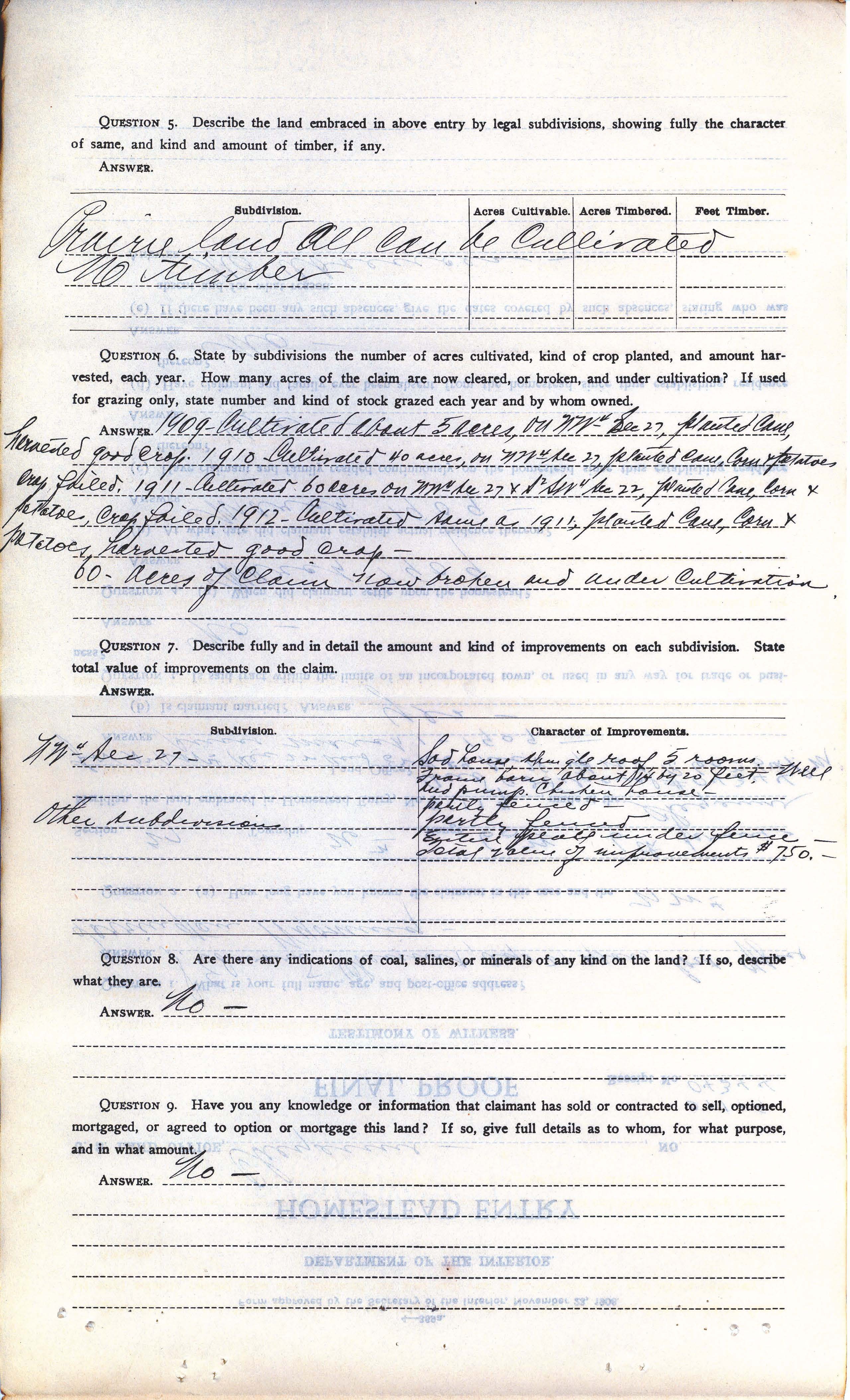
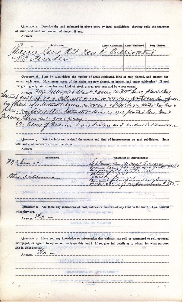
QUESTION 5. Describe the land embraced in above entry by legal subdivisions, showing fully the character of same, and kind and amount of timber, if any.
ANSWER.
Subdivision Acres cultivable. Acres timbered. Feet timber.
Prairie land all can be cultivated
No timber
QUESTION 6. State by subdivisions the number of acres cultivated, kind of crop planted, and amount harvested, each year. How many acres of the claim are now cleared, or broken, and under cultivation? If used for grazing only, state number and kind of stock grazed each year and by whom owned.
ANSWER. 1909- Cultivated about 5 acres, on NW¼ Sec 27, planted cane, harvested good crop. 1910- Cultivated 40 acres, on NW¼ Sec 27, planted cane, corn, & potatoes crop failed. 1911- Cultivated 60 acres, on NW¼ Sec 27 & S ½ SW ¼ Sec 22, planted cane, corn & potatoes, crop failed. 1912- Cultivated same as 1911, planted cane, corn & potatoes, harvested good crop-
60-acres of claim now broken and under cultivation.
QUESTION 7. Describe fully and in detail the amount and kind of improvements and number of acres under cultivation on each subdivision. State total value of improvements on the claim.
ANSWER.
Subdivision Character of improvements
NW¼ Sec. 27 Sod house, shingle roof, 5 rooms. Frame barn about 14 by 20 feet. Well and pump. Chicken house-
partly fenced-
Other subdivisions partly fenced
Entire place under fence-
Total value of improvements $750.-
QUESTION 8. Are there any indications of coal, salines, or minerals of any kind on the land? If so, describe what they are.
ANSWER. No-
QUESTION 9. Have you any knowledge or information that claimant has sold, optioned, mortgaged, or agreed to option or mortgage this land? If so, give full details as to whom, for what purposed and in what amount?
ANSWER. No-
Federal records are in the public domain
Public domain
Document
Homestead National Historical Park, Code: HOME
Homestead National Historical Park, Gage County, Nebraska
Latitude: 40.2879981994629, Longitude: -96.8339004516602
Latitude: 40.2879981994629, Longitude: -96.8339004516602
unknown
01/01/1908 - 12/30/1924
Land Entry Case Files: Homestead Final Certificates. Record Group 49: Records of the Bureau of Land Management. National Archives and Records Administration.
Public Can View
Organization: Homestead National Historical Park
Address: 8523 W State Hwy 4, Beatrice, NE 68310
Address: 8523 W State Hwy 4, Beatrice, NE 68310
Sunday, May 16, 2021 10:49:46 AM
Thursday, July 17, 2025 7:03:47 PM
Charles Speese - Wyoming_Page_19.jpg
Monday, January 1, 0001 12:00:00 AM
jpg
1.1 MB
Historic