Select Item below to DOWNLOAD - Once item is selected, right click and choose 'save as'
1c44af3d5bf14a0dbb7b4215cd60a262
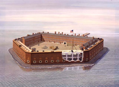
Aerial of Fort Sumter, c1861. Perspective allows the interior parade ground, the wharf, barracks, and Officers' Quarters to be viewed over the 50 foot walls. The left face in the foreground is cutaway to show gun emplacements.
Aerial of Fort Sumter, c1861. Perspective allows the interior parade ground, the wharf, barracks, and Officers' Quarters to be viewed over the 50 foot walls. The left face in the foreground is cutaway to show gun emplacements.
Abbr=PUB
U.S. National Park Service
Project=Folder/Handbook ; Reflective Art
Government owns art and all reproduction rights.
Public domain
Image
Fort Sumter and Fort Moultrie National Historical Park, Code: FOSU
Fort Sumter and Fort Moultrie National Historical Park, Charleston County, South Carolina
Latitude: 32.7536010742188, Longitude: -79.8793029785156
Latitude: 32.7536010742188, Longitude: -79.8793029785156
Image Management System : IMS 09021
20190904
01/01/1984 - 12/30/1984
Image_Size=36" x 28"; Count:1/1; Publications' Fort Sumter National Monument park handbook, pages 8-9 and brochure
MC CC
Public Can View
Organization: Harpers Ferry Center
Address: Harpers Ferry Center, 67 Mather Place, Harpers Ferry, WV, 25425, 304-535-5050
Address: Harpers Ferry Center, 67 Mather Place, Harpers Ferry, WV, 25425, 304-535-5050
Monday, October 7, 2019 2:38:00 PM
Monday, October 7, 2019 2:38:00 PM
09021.jpg
jpg
39.3 kB
Museum