Select Item below to DOWNLOAD - Once item is selected, right click and choose 'save as'
1a4645e2-6489-4d8e-80d4-517b0fabf4ae
Valley of Ten Thousand Smokes
Valley of Ten Thousand Smokes
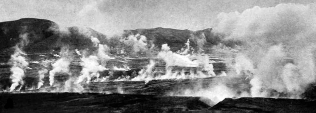
Photograph of the Valley of Ten Thousand Smokes. In 1917, the northwest arm of the valley was filled
with steaming fumaroles. The view is looking northwest toward the Buttress Range on the left side of the photograph.
Permission must be secured from the individual copyright owners to reproduce any copyrighted materials contained within this website. Digital assets without any copyright restrictions are public domain.
National Geographic Society photograph by Robert Griggs (Griggs 1922, p. 234).
Public domain:Full Granting Rights
Image
Alagnak Wild River, Code: ALAG
Katmai National Park and Preserve, Code: KATM
Katmai National Park and Preserve, Code: KATM
Alagnak Wild River, Lake and Peninsula Borough, Alaska
Latitude: 59.003101348877, Longitude: -156.082000732422
Katmai National Park and Preserve, Alaska
Latitude: 58.5661087036133, Longitude: -154.889404296875
Latitude: 59.003101348877, Longitude: -156.082000732422
Katmai National Park and Preserve, Alaska
Latitude: 58.5661087036133, Longitude: -154.889404296875
01/01/0001
Public Can View
Friday, September 3, 2021 12:04:33 PM
Friday, September 3, 2021 1:01:57 PM
18_KATM_Griggs 1922 VTTS p 234.jpg
Monday, January 1, 0001 12:00:00 AM
jpg
98.0 kB
Scenic