Select Item below to DOWNLOAD - Once item is selected, right click and choose 'save as'
0ff8e9fd-021f-44d7-84c8-b3d2f25357d3
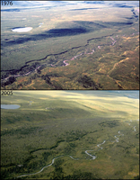
Changing Treelines at Savage River: 1976-2005
A photo pair showing Changing Treelines at Savage River: 1976-2005
Just upstream from the Savage River Bridge and check station, spruce have increased in density and expanded into previously unforested areas along the Upper Savage River.
Original year: 1976; Rephoto year: 2005
U.S. National Park Service
Photos and photo pairs are pre-approved for educational use ONLY. To use them in educational products, credit them the same way as they are credited on the website, Photo Credit: Original photographer: Fred Dean; Rephoto photographer: Carl Roland. For any other use beyond education, contact Denali National Park and Preserve for additional copyright information on specific images of interest.
Original photographer: Fred Dean; Rephoto photographer: Carl Roland
Restrictions apply on use and/or reproduction
Image
Denali National Park and Preserve, Code: DENA
Savage River, Alaska Range mountains, Alaska
Latitude: 63.688083, Longitude: -149.253837
Denali National Park and Preserve, Alaska
Latitude: 63.3182792663574, Longitude: -150.602905273438
Latitude: 63.688083, Longitude: -149.253837
Denali National Park and Preserve, Alaska
Latitude: 63.3182792663574, Longitude: -150.602905273438
2016/03/03
Public Can View
Person: Digital Manager
Organization: US National Park Service
Address: Denali National Park and Preserve, P.O. Box 9, Denali Park, AK 99755
Organization: US National Park Service
Address: Denali National Park and Preserve, P.O. Box 9, Denali Park, AK 99755
Thursday, June 6, 2024 4:51:53 PM
Thursday, June 6, 2024 4:51:53 PM
065557_21.jpg
jpg
265.3 kB
Scenic
,
Historic
,
Monitoring