Select Item below to DOWNLOAD - Once item is selected, right click and choose 'save as'
0800076e-ad2f-4f5d-aaf1-4a79c6b0b842
Columbia River Flood Basalt
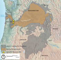
Map showing the distribution of the Columbia River Flood Basalt and the Wanapum basalt. The Wanapum basalt underlies both units of the Fort Vancouver National Historic Site.
Map showing the distribution of the Columbia River Flood Basalt.
The yellow stars mark the locations of Fort Vancouver National Historic Site units. Map by Trista Thornberry-Ehrlich (Colorado State University) with information from Alt and Hyndman (1995, http://
geology.isu.edu/Digital_Geology_Idaho/Module10/mod10.htm; accessed 29 July 2013).
Permission must be secured from the individual copyright owners to reproduce any copyrighted materials contained within this website. Digital assets without any copyright restrictions are public domain.
Base map by Tom
Patterson (NPS), available at http://www.shadedrelief.com/physical/index.htm
Public domain:Full Granting Rights
Image
Fort Vancouver National Historic Site, Code: FOVA
Fort Vancouver National Historic Site
Latitude: 45.623851776123, Longitude: -122.662101745605
Latitude: 45.623851776123, Longitude: -122.662101745605
01/01/0001
Public Can View
Friday, July 2, 2021 3:31:01 PM
Friday, July 2, 2021 3:31:01 PM
06_FOVA_CRB_Wanapum_Extent_Map-01.jpg
Monday, January 1, 0001 12:00:00 AM
jpg
2.8 MB
Scenic