Select Item below to DOWNLOAD - Once item is selected, right click and choose 'save as'
0132cae55fd64398bb107fe5b7fd354c
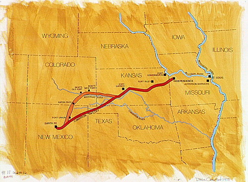
Map showing the Santa Fe Trail.
Map showing the Santa Fe Trail.
Abbr=AVA
U.S. National Park Service
Reflective Art
Government owns art and all reproduction rights.
Public domain
Image
Fort Larned National Historic Site, Code: FOLS
Fort Larned National Historic Site, Pawnee County, Kansas
Latitude: 38.1845016479492, Longitude: -99.2170028686523
Latitude: 38.1845016479492, Longitude: -99.2170028686523
Image Management System : IMS 01312
20190904
01/01/1979 - 12/30/1979
Image_Size=W: 20" x H: 15"; Metric_Size=W: 50.76CM X H: 38.07CM; AVA Project #44; Slide Show #280, Plate 11
B9
Public Can View
Organization: Harpers Ferry Center
Address: Harpers Ferry Center, 67 Mather Place, Harpers Ferry, WV, 25425, 304-535-5050
Address: Harpers Ferry Center, 67 Mather Place, Harpers Ferry, WV, 25425, 304-535-5050
Monday, October 7, 2019 3:05:19 PM
Monday, October 7, 2019 3:05:19 PM
01312.JPG
jpg
109.0 kB
Museum