Zion National Park, Utah
NPS Museum Accession Number : ZION-00768
Zion Legacy HPC Database Number : HPC-007055
Organization: Zion National Park
Position: Museum Curator
Address: Zion National Park, State Route 9, Springdale, UT 84767
Email: zion_museum@nps.gov
Albert E. Jones property, east of Virgin River, south of park boundary with house and outbuildings. ; ZION Museum and Archives Image 103_01_004 ; ZION 8298
John Dennet Jr. Property and out buildings, east of Virgin River, south of park boundary. ; ZION Museum and Archives Image 103_01_003 ; ZION 8336
Albert E. Jones property, east of Virgin River, south of park boundary, three men standing near the fence. ; ZION Museum and Archives Image 103_01_002 ; ZION 7984
Albert E. Jones property, east of Virgin River, south of park boundary. ; ZION Museum and Archives Image 103_01_001 ; ZION 7983
E.C. and H.F. Winder properties with house, east of Virgin River, south of park boundary. ; ZION Museum and Archives Image 103_01_058 ; ZION 8301
E.C. and H.F. Winder properties east of Virgin River, south of park boundary, with house. ; ZION Museum and Archives Image 103_01_057 ; ZION 8300
E.C. and H.F. Winder properties east of Virgin River, south of park boundary, with outbuildings. ; ZION Museum and Archives Image 103_01_056 ; ZION 8297
E.C. and H.F. Winder properties east of Virgin River, south of park boundary with outbuildings. ; ZION Museum and Archives Image 103_01_055 ; ZION 8296
Samuel Heber and Mildred C. Crawford property east of Virgin River, south of park boundary, with sheds and old car. ; ZION Museum and Archives Image 103_01_042 ; ZION 13672
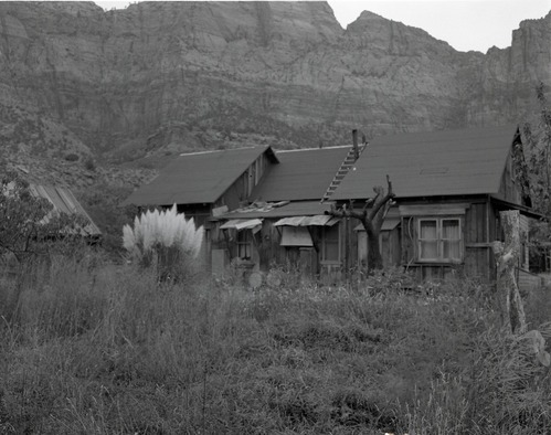
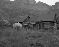
Samuel Heber and Mildred C. Crawford property, east of Virgin River, south of park boundary with house. ; ZION Museum and Archives Image 103_01_041 ; ZION 8263
Ranger at the Samuel Heber and Mildred C. Crawford property east of Virgin River, south of park boundary, with rabbit hutch. ; ZION Museum and Archives Image 103_01_040 ; ZION 7613
Shed belonging to Samuel Heber and Mildred C. Crawford property, east of Virgin River, south of park boundary. ; ZION Museum and Archives Image 103_01_039 ; ZION 8358
Samuel Heber and Mildred C. Crawford property, east of Virgin River, south of park boundary with house. ; ZION Museum and Archives Image 103_01_038 ; ZION 8229
Bridge across Virgin River near South Entrance, access to properties east of river. ; ZION Museum and Archives Image 103_01_006 ; ZION 9629
Bridge across Virgin River near South Entrance - access to properties east of river. ; ZION Museum and Archives Image 103_01_005 ; ZION 10527
Rhoda Crawford property east of Virgin River, south of park entrance; appraisal of property pending government purchase. ; ZION Museum and Archives Image 103_01_037 ; ZION 8228
Rhoda Crawford property east of Virgin River, south of park entrance with house; appraisal of property pending government purchase. ; ZION Museum and Archives Image 103_01_036 ; ZION 8227
Rhoda Crawford property east of Virgin River, south of park entrance; appraisal of property pending government purchase. ; ZION Museum and Archives Image 103_01_035 ; ZION 8357
B&W negative showing Rhoda Crawford property east of Virgin River, south of park entrance, with house; appraisal of property pending government purchase, section 28, T 41 S, R 10 W. [Pits, scratches] ; ZION Museum and Archives Image 103_01_034 ; ZION 8356
Boundary change study, land east of West Temple, south of entrance station. ; ZION Museum and Archives Image 103_01_027 ; ZION 8348
Arden Schieffer's property east of Virgin River, south of park boundary, with cabin; appraisal of property pending government purchase. ; ZION Museum and Archives Image 103_01_011 ; ZION 9635
Arden Schieffer's property east of Virgin River, south of park boundary. ; ZION Museum and Archives Image 103_01_008 ; ZION 9631
Arden Schieffer's property east of Virgin River, south of park boundary. Appraisal of property pending government purchase. ; ZION Museum and Archives Image 103_01_007 ; ZION 9630
Head of Kolob Canyon north of Lava Point, sections 30 and 31, T 39S, R 10 W, for boundary change. ; ZION Museum and Archives Image 103_01_021 ; ZION 8342
Looking east from Lava Point, sections 30 and 31, T 39S, R 10 W, head of Kolob Canyon, for boundary change. ; ZION Museum and Archives Image 103_01_020 ; ZION 8341
View looking east from Lava Point, sections 30 and 31, T 39S, R 10 W, head of Kolob Canyon, for boundary change. ; ZION Museum and Archives Image 103_01_019 ; ZION 8340
View looking north east from Lava Point, sections 30 and 31, T 39S, R 10 W for boundary change. ; ZION Museum and Archives Image 103_01_018 ; ZION 8339
View looking northeast from Lava Point, sections 30 and 31, T 39S, R 10 W for boundary change. ; ZION Museum and Archives Image 103_01_017 ; ZION 8338
View looking north from Spendlove Knoll at Firepit Knoll and Job's Head for boundary change. ; ZION Museum and Archives Image 103_01_016 ; ZION 8337
View looking northwest from Spendlove Knoll for boundary change. ; ZION Museum and Archives Image 103_01_015 ; ZION 9633
View looking west from Spendlove Knoll for boundary change. ; ZION Museum and Archives Image 103_01_024 ; ZION 8345
View looking west from Spendlove Knoll for boundary change. ; ZION Museum and Archives Image 103_01_023 ; ZION 8344
View looking northeast from Spendlove Knoll, for boundary change. ; ZION Museum and Archives Image 103_01_022 ; ZION 8343
Blue Springs Lake and dam, aerial view 3/4-mile north of park boundary. ; ZION Museum and Archives Image 103_01_025 ; ZION 8346
Samuel Crawford property after removal of sheds. ; ZION Museum and Archives Image 103_01_053 ; ZION 8294
Samuel Crawford property sheds before removal. ; ZION Museum and Archives Image 103_01_054 ; ZION 8295
Samuel Crawford property after removal of sheds. ; ZION Museum and Archives Image 103_01_051 ; ZION 7239
Samuel Crawford property sheds before removal. ; ZION Museum and Archives Image 103_01_052 ; ZION 8293
Samuel Crawford property with sheds and rubbish removed. ; ZION Museum and Archives Image 103_01_049 ; ZION 10603
Samuel Crawford property with sheds and rubbish. ; ZION Museum and Archives Image 103_01_050 ; ZION 10604
Samuel Crawford property with trash heaps removed. ; ZION Museum and Archives Image 103_01_047 ; ZION 10601
Samuel Crawford property with trash heaps. ; ZION Museum and Archives Image 103_01_048 ; ZION 10602
Samuel Crawford property after removal of buildings. ; ZION Museum and Archives Image 103_01_046 ; ZION 10600
Samuel Crawford property building before removal. ; ZION Museum and Archives Image 103_01_045 ; ZION 10599
Samuel Crawford property buildings before dismantling and area clean-up. ; ZION Museum and Archives Image 103_01_044 ; ZION 10598
Samuel Crawford property building before dismantling and area clean-up. ; ZION Museum and Archives Image 103_01_043 ; ZION 10597
Lava Point and Kolob Terrace roads junction, aerial. ; ZION Museum and Archives Image 103_01_026 ; ZION 8347
Debris from old structures, logs in the meadow with trees in background. ; ZION Museum and Archives Image 103_01_013 ; ZION 9637
Unsightly conditions such as these occurred along the highway after original owners moved away. Small table, washtub and water spigot are visible among buildings debris. ; ZION Museum and Archives Image 103_01_014 ; ZION 9638