Select Item below to DOWNLOAD - Once item is selected, right click and choose 'save as'
f7ec1899-ce71-4b88-ac71-e874f8efdc45
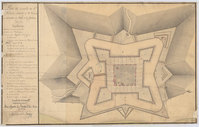
1785 Map and plan of the Castillo.
Black and white sketch plan of the fortress rooms and defenses.
1785 Map and plan of the Castillo. Showing the layout of the rooms and the immediate outer defenses.
Permission must be secured from the individual copyright owners to reproduce any copyrighted materials contained within this website. Digital assets without any copyright restrictions are public domain.
NPS
Public domain:Full Granting Rights
Image
Castillo de San Marcos National Monument, Code: CASA
Castillo de San Marcos National Monument, St. Johns County, Florida
Latitude: 29.8978996276855, Longitude: -81.3122024536133
Latitude: 29.8978996276855, Longitude: -81.3122024536133
01/01/1785
03/02/2010
Public Can View
Thursday, June 18, 2020 12:10:27 PM
Thursday, June 18, 2020 12:10:27 PM
1785 map.jpg
Tuesday, March 2, 2010 8:35:48 PM
jpg
2.3 MB
Scenic