Select Item below to DOWNLOAD - Once item is selected, right click and choose 'save as'
f47a4a85-2c7e-4d47-bafc-99539ce5405d
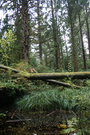
Clay Pit Pond
Clay pit pond, covered in fallen leaves. Ferns and huckleberry line the shoreline.
Clay pit pond, covered in fallen leaves. Ferns and huckleberry line the shoreline.
Permission must be secured from the individual copyright owners to reproduce any copyrighted materials contained within this website. Digital assets without any copyright restrictions are public domain.
Public domain
Image
Lewis and Clark National Historical Park, Code: LEWI
Lewis and Clark National Historical Park
Latitude: 46.2874488830566, Longitude: -124.065803527832
Latitude: 46.2874488830566, Longitude: -124.065803527832
11/02/2013
11/02/2013
Public Can View
Person: Jill Harding
Organization: NPS
Role: Head of Visitor Services
Position: Head of Visitor Services
Address: 92343 Fort Clatsop Rd, Astoria OR 97103
Email: jill_harding@nps.gov
Organization: NPS
Role: Head of Visitor Services
Position: Head of Visitor Services
Address: 92343 Fort Clatsop Rd, Astoria OR 97103
Email: jill_harding@nps.gov
Sunday, October 13, 2024 6:09:18 PM
Sunday, October 13, 2024 6:09:49 PM
KK_Clay Pit Pond 4_2013.JPG
Canon Canon, Canon EOS DIGITAL REBEL XT
1/60 sec at f / 5
18 mm
ISO 400
Saturday, November 2, 2013 2:23:31 AM
jpg
5.5 MB
Scenic