Select Item below to DOWNLOAD - Once item is selected, right click and choose 'save as'
f1c32656-ec33-4fd1-9537-7652bb241f83
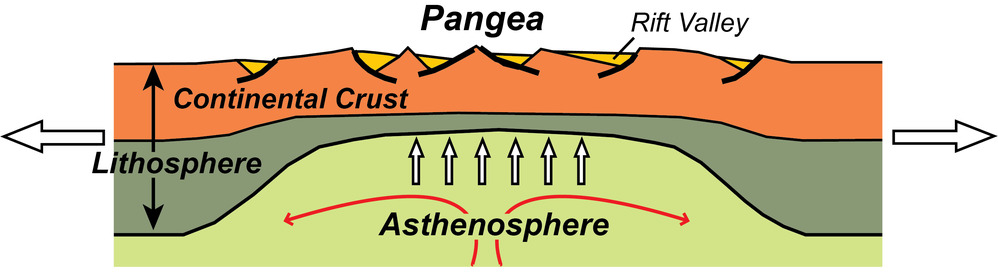
Continental Rift Diagram
illustration of the upper layers of the earth showing a rift zone
Passive continental margins abutting the Atlantic Ocean and Gulf of Mexico developed as a large continent, Pangea, ripped apart about 200 million years ago.
Permission must be secured from the individual copyright owners to reproduce any copyrighted materials contained within this website. Digital assets without any copyright restrictions are public domain.
Modified from “Parks and Plates: The Geology of our National Parks, Monuments and Seashores,” by Robert J. Lillie, New York, W. W. Norton and Company, 298 pp., 2005, www.amazon.com/dp/0134905172.
Public domain:Full Granting Rights
Image
Geologic Resources Division, Code: GRD
01/30/2020
01/30/2020
Public Can View
Thursday, January 30, 2020 12:50:24 PM
Thursday, January 30, 2020 12:50:24 PM
illustration continental rift@10x.jpg
Thursday, January 30, 2020 7:01:32 PM
jpg
563.0 kB
Scenic