Select Item below to DOWNLOAD - Once item is selected, right click and choose 'save as'
ef956f0d-124b-49a9-b8a6-893bd6be6c47
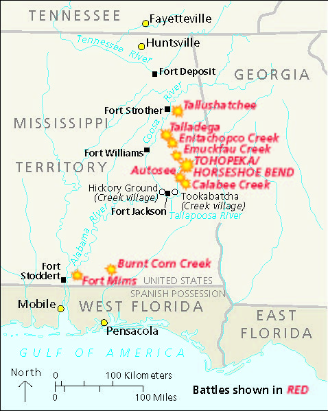
Creek War Map, 1813 through 1814 - Horseshoe Bend National Military Park
Historical map of Creek War battle sites circa 1813 to 1814. Starburst icons and red text mark nine battle sites, which are clustered together near the center of the map in and around present-day Horseshoe Bend National Military Park in Alabama.
Screen-viewable file; Adobe print production files can be downloaded from the Compressed zip Version link
Map Projection: Other; Map Type: unassigned
U.S. National Park Service
The National Park Service maps are government produced and are in the public domain. Anyone may, without restriction under U.S. copyright laws: Reproduce the work in print or digital form; Create derivative works; Perform the work publicly; Display the work; Distribute copies or digitally transfer the work to the public by sale or other transfer of ownership, or by rental, lease, or lending. Please note, a user who modifies and/or republishes National Park Service maps are responsible for any problems encountered with the maps, due to their change or modification.
Public domain
Document
Horseshoe Bend National Military Park, Code: HOBE
Horseshoe Bend National Military Park, Tallapoosa County, Alabama
Latitude: 32.9766998291016, Longitude: -85.7341003417969
Latitude: 32.9766998291016, Longitude: -85.7341003417969
2025/02/11
Public Can View
Person: Harpers Ferry Center
Organization: US National Park Service
Address: Harpers Ferry Center, Harpers Ferry, WV
Email: HFC_Cartography@nps.gov
Organization: US National Park Service
Address: Harpers Ferry Center, Harpers Ferry, WV
Email: HFC_Cartography@nps.gov
Wednesday, February 12, 2025 2:14:14 PM
Friday, September 26, 2025 11:35:48 PM
HOBEmap3.pdf
pdf
304.2 kB
Map