Select Item below to DOWNLOAD - Once item is selected, right click and choose 'save as'
ea90eb5a-762d-4138-bc56-8eb33d5675e4
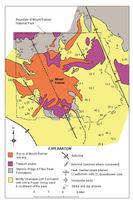
Figure 7: Simplified geologic map of Mount Rainier.
Map of major geologic features in and around Mount Rainier National Park.
Figure 7: Simplified geologic map of Mount Rainier National Park showing rock units and the location of the synclines, anticlines, faults, and dip of beds.
Permission must be secured from the individual copyright owners to reproduce any copyrighted materials contained within this website. Digital assets without any copyright restrictions are public domain.
NPS image.
Public domain:Full Granting Rights
Image
Geologic Resources Division, Code: GRD
Mount Rainier National Park, Code: MORA
Mount Rainier National Park, Code: MORA
Mount Rainier National Park, Washington
Latitude: 46.865608215332, Longitude: -121.682601928711
Latitude: 46.865608215332, Longitude: -121.682601928711
01/01/0001
Public Can View
Friday, December 1, 2023 11:03:53 PM
Friday, December 1, 2023 11:05:45 PM
MORA_GRI_Fig7.jpg
Monday, January 1, 0001 12:00:00 AM
jpg
148.4 kB
Scenic