Select Item below to DOWNLOAD - Once item is selected, right click and choose 'save as'
e73853975041453d9ab510da0e7b9bfb
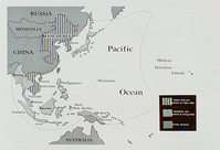
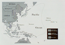
Map and type overlay highlighting Japanese conquests to December 7, 1941 and August 6, 1942
Map and type overlay highlighting Japanese conquests to December 7, 1941 and August 6, 1942
Map also shows Allied nations. Map includes Russia, Mongolia, China, Manchuria, Korea, Japan, Burma, French Indochina, Philippines, Thailand, Malaya, Sumatra, Java, Borneo, Netherlands' New Guinea, Northeastern New Guinea, Australia, Marianas, Midway, and Hawaiian Islands.
Abbr=AVA
U.S. National Park Service
Reflective Art
Government owns art and all reproduction rights.
Public domain
Image
War in the Pacific National Historical Park, Code: WAPA
War in the Pacific National Historical Park, Guam , Guam
Latitude: 13.3905000686646, Longitude: 144.654006958008
Latitude: 13.3905000686646, Longitude: 144.654006958008
Image Management System : IMS 00995
20190904
Image_Size=W: 20" x H: 15"; Metric_Size=W: 50.76CM X H: 38.07CM; AVA Project #67, Plate 4
A6
Public Can View
Organization: Harpers Ferry Center
Address: Harpers Ferry Center, 67 Mather Place, Harpers Ferry, WV, 25425, 304-535-5050
Address: Harpers Ferry Center, 67 Mather Place, Harpers Ferry, WV, 25425, 304-535-5050
Monday, October 7, 2019 3:07:04 PM
Monday, October 7, 2019 3:07:04 PM
00995.JPG
jpg
62.0 kB
Museum