Select Item below to DOWNLOAD - Once item is selected, right click and choose 'save as'
e6c337a2-d82d-43aa-942e-882b09ee3b87
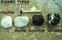
Pumice Types
Photograph showing representative pumices from 1912 eruption.
Photograph showing representative pumices from 1912 eruption. From left to right, the pumice from
the 1912 eruption included white crystal-poor rhyolite, pale gray crystal-rich dacite, black crystal-rich andesite, and
rhyolite-andesite banded pumice.
Permission must be secured from the individual copyright owners to reproduce any copyrighted materials contained within this website. Digital assets without any copyright restrictions are public domain.
USGS-CalVO photograph by Wes Hildreth.
Public domain:Full Granting Rights
Image
Alagnak Wild River, Code: ALAG
Katmai National Park and Preserve, Code: KATM
Katmai National Park and Preserve, Code: KATM
Alagnak Wild River, Lake and Peninsula Borough, Alaska
Latitude: 59.003101348877, Longitude: -156.082000732422
Katmai National Park and Preserve, Alaska
Latitude: 58.5661087036133, Longitude: -154.889404296875
Latitude: 59.003101348877, Longitude: -156.082000732422
Katmai National Park and Preserve, Alaska
Latitude: 58.5661087036133, Longitude: -154.889404296875
09/23/2016
09/23/2016
Public Can View
Friday, September 3, 2021 12:00:52 PM
Friday, September 3, 2021 1:01:56 PM
12_KATM_Fig. 4-Pumice types.jpg
Friday, September 23, 2016 2:04:28 PM
jpg
3.3 MB
Scenic