Select Item below to DOWNLOAD - Once item is selected, right click and choose 'save as'
e3a058cd-ae19-4698-92b9-2dc5808537ea
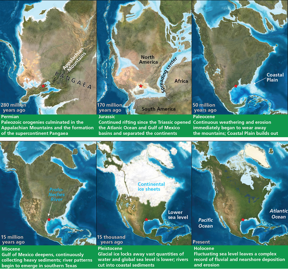
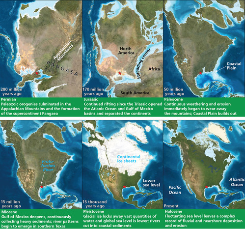
Paleogeographic maps of North America
Paleogeographic maps of North America. Six maps show the changes in the location and configuration of North America over the past 260 million years ago. The following text is on the maps:
1. 280 million years ago (Permian period): Paleozoic orogenies culminated in the Appalachian Mountains and the formation of the supercontinent Pangaea.
2. 170 million years ago (Jurassic Period): Continued rifting since the Triassic opened the Atlantic Ocean and Gulf of Mexico basins and separated the continents.
3. 50 million years ago (Eocene Epoch): Continuous weathering and erosion wears away the mountains; Coastal Plain builds out.
4. 15 million years ago (Miocene Epoch): Gulf of Mexico deepens, continuously collecting heavy sediments; river patterns begin to emerge in southern Texas.
5. 15,000 years ago (Pleistocene Epoch): Glacial ice from continental ice sheets locks away vast quantities of water and global sea level is lower; rivers cut into coastal sediments.
6. Present day (Holocene Epoch): Fluctuating sea level l
The red star indicates the approximate location of Big Thicket National Preserve.
Permission must be secured from the individual copyright owners to reproduce any copyrighted materials contained within this website. Digital assets without any copyright restrictions are public domain.
Graphic complied by
Trista L. Thornberry-Ehrlich (Colorado State University). Basemaps are from “North American Key Time
Slices” © 2013 Colorado Plateau Geosystems, Inc; used under license. Refer to http://deeptimemaps.com/
for additional information.
Public domain:Full Granting Rights
Image
Big Thicket National Preserve, Code: BITH
Big Thicket National Preserve, Texas
Latitude: 30.1642608642578, Longitude: -94.3181228637695
Latitude: 30.1642608642578, Longitude: -94.3181228637695
01/01/0001
Public Can View
Tuesday, July 20, 2021 4:49:58 PM
Tuesday, July 20, 2021 5:51:45 PM
05_BITH_Paleogeographic_0613-2017_tte-01.jpg
Monday, January 1, 0001 12:00:00 AM
jpg
3.3 MB
Scenic