Select Item below to DOWNLOAD - Once item is selected, right click and choose 'save as'
e2705fd5-ab92-4b64-a696-b3075bd299df
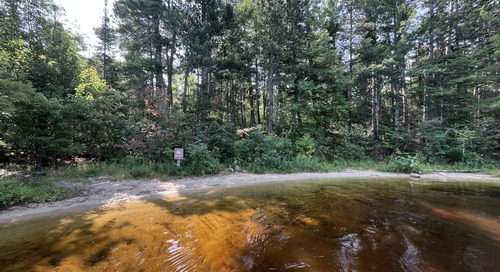
Houseboat Sand Point Island East at Sand Point Lake, Sand mooring; Sand Point Island East (S16) From Water
A calm, forested lakeshore with clear brown water, dense trees, and a small houseboat sign near the shoreline.
Voyageurs Houseboat
U. S. National Park Service
This digital asset is in the public domain. When using this asset for any purpose, including online, credit: 'Courtesy U.S. National Parks'
Public domain
S16, (Voyageurs Map Number)
, Sand Point Island East, (Voyageurs Site Name)
, Houseboat, (Voyageurs Site Type)
, Sand Point Lake, (Voyageurs Location)
, Sand, (Voyageurs Mooring)
, Sand Point Island East, (Voyageurs Site Name)
, Houseboat, (Voyageurs Site Type)
, Sand Point Lake, (Voyageurs Location)
, Sand, (Voyageurs Mooring)
Image
Voyageurs National Park, Code: VOYA
Sand Point Lake
Sand Point Island East
Latitude: 48.414, Longitude: -92.467
Voyageurs National Park, Minnesota
Latitude: 48.48828125, Longitude: -92.8048095703125
Sand Point Island East
Latitude: 48.414, Longitude: -92.467
Voyageurs National Park, Minnesota
Latitude: 48.48828125, Longitude: -92.8048095703125
07/25/2025 | 2022/08/18
07/25/2025
Public Can View
Person: Program Manager
Organization: US National Park Service
Address: Voyageurs National Park Headquarters, 360 Hwy 11 East, International Falls , MN 56649
Organization: US National Park Service
Address: Voyageurs National Park Headquarters, 360 Hwy 11 East, International Falls , MN 56649
Tuesday, January 3, 2023 10:11:23 PM
Saturday, July 26, 2025 2:06:23 PM
From Water (5).JPG
jpg
3.3 MB
Inventory